This zoomed shot of approximately 2.5 miles from St Martin's Battery on the Western Heights shows the western terminator of the landslide as a vertical line running down the center of the photograph:
The "smeared" cliff face to the right of the terminator is an oblique view of the area affected. Note the thin horizontal chalk crevasse on the cliff top above and beyond the top edge of the "smear" but just below the skyline.
The photo was taken about an hour before high tide and consequently it doesn't show the full height or spread of the spoil heap:
This section of cliffs is shown in the Rough and Ready White Cliffs of Dover Video (along with a close-up of HM Dover Coastguard station mentioned below) that was filmed at the same time as the main photo was taken.
This next photo has been extracted from the Daily Telegraph video that follows it.
The video was taken soon after the cliff collapsed in 2012 and the image shows the coastline a little further to the east (ie out of sight of my vantage point at St Martin's Battery):
The "horizontal chalk crevasse" in the main photo is the top right boundary of the lozenge-shaped area of cliffs that might be where the next substantial cliff fall into the English Channel occurs.
The one-minute Daily Telegraph video, "White cliffs of Dover fall into the sea" (no commentaty):
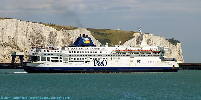
A final photograph taken on the 22nd of July 2010 prior to the rockfall of 2012:
P&O Ferries cross-channel passenger ferry, MS Pride of Calais in front of the Eastern Arm pier and Eastern Docks of Dover harbour (Port of Dover).
On the cliff top behind the ship's funnel is a foreshortened view of the top-left chalk crevasse shown in the video still; the area of the 2012 cliff fall is to its left (nearer the stern of the ship).
MS Pride of Calais was a cross-channel ferry owned and operated by P&O Ferries. She operated the Dover to Calais route between 1987 and 2012.
In early 2013, under bareboat charter to Transeuropa Ferries, she served on their Ramsgate to Ostend route and was re-named MS Ostend Spirit.
After further lay-up in the Port of Tilbury she was sold for scrap and finally beached at a salvage yard in Turkey on 13 November 2013. (3)
The White Cliffs of Dover, part of the North Downs formation, is the region of English coastline facing the Strait of Dover and France.
The cliff face, which reaches a height of 350 feet (110 m), owes its striking appearance to its composition of chalk accented by streaks of black flint.
The cliffs, on both sides of the town of Dover in Kent, stretch for eight miles (13 km). A section of coastline encompassing the cliffs was purchased by the National Trust in 2016. (4)
Also on this blog:
 |
| Shakespeare Cliff |
 |
| East Cliff and History |
The post contains close-up of three items of historical interest.
(1) Abridged from White cliffs of Dover section falls into sea:
A large section of Dover's famous white cliffs has broken away and crashed into the Channel, according to the coastguard.
Tonnes of rock collapsed into the sea between Langdon Cliffs and South Foreland Lighthouse.
Dover Coastguard said no-one was injured during the "substantial" rockfall, which happened in an area know locally as Crab Bay.
The National Trust has put up warning signs to alert walkers.
It is thought freezing conditions over the winter may have weakened the chalk cliffs.
(2) The main photograph was taken from St Martin's Battery on the Western Heights on the 24th of April during a permitted Coronavirus bike ride.
(3) Extract from MS Pride of Calais.
(4) Extract from White Cliffs of Dover
See the Maritime and Coastguard Agency.
Covid-19 lockdown: a cycling route map and biometrics can be seen on this Polar Flow web page.
Abridged versions of this post are also on Facebook and Twitter.


No comments:
Post a Comment