Red circle: East Kent Hospitals University NHS Foundation Trust
Orange circle: Medway NHS Foundation Trust
Black circle: Maidstone and Tunbridge Wells NHS Trust
Yellow circle: Dartford and Gravesham NHS Trust
The map shows "A full breakdown on where patients in Kent have died from COVID-19" (Kent Live)
Clicking on the "X" in each of the Kent NHS Trust areas will reveal the current number of deaths for that Trust:
The map will be automatically updated.
This link provides more information for Kent and for the rest of the UK. Clicking on "Local Deaths" (on the right under the blue banner) provides more data than that the web page initially displays.
At the time of writing (3rd of April, 2020) there have been 33 coronavirus-related deaths in Kent of which 13 have occurred in the East Kent Hospitals University NHS Foundation Trust.
Dover's Buckland Hospital (in my hometown) is shown on the map whereas, for example, the nearby Royal Victoria Hospital, Folkestone is not.
This is something of a personal wake-up call because I haven't watched any regional news programs for more years than I can remember.
Instead, I have been focusing my attention on the main BBC News television programs supplemented by looking at their teletext service for London and the South East.
When it became apparent that the teletext stories weren't being regularly updated I set up Google news alerts and it is through these that I've discovered the true situation in Kent - a sobering experience.
(Also see 9 April 2020: Covid-19 fatality statistics for Dover, UK)
This photo of Buckland Hospital was taken on Sunday, 29th of March, 2020 during a permitted coronavirus lockdown bike ride and also appears on Facebook and Twitter:
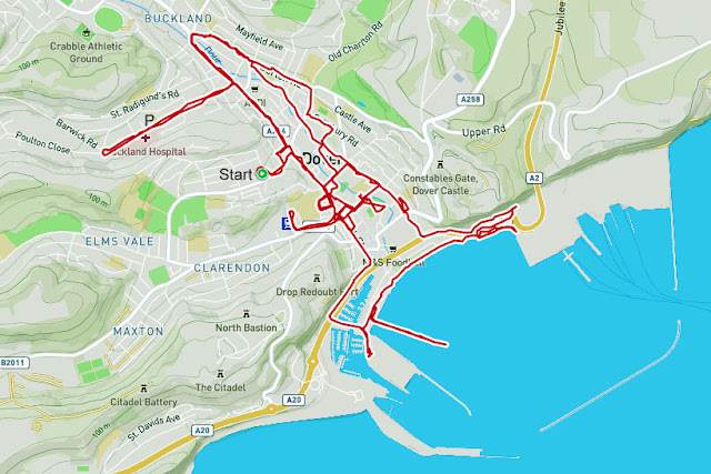
The location this photo was taken from is marked "P" on the cycling route map for that day:
Original map and biometrics at this Polar Flow web page.


No comments:
Post a Comment