Wednesday 29 April 2020

29 April 2020: Covid-19 fatality statistics for Dover, UK

Spending more time at home, along with cycling (my Coronavirus lockdown exercise) being a solitary activity, means that I occasionally find I'm living life in a bubble.

I record and watch BBC news broadcasts about the pandemic several times a day but I am oblivious of the increasing numbers of tragedies that are happening right here in my hometown of Dover, England:


Covid-19 pandemic fatality statistics for Ashford, Canterbury, Dartford and Dover up to 17th April, 2020. Figures show deaths in Care Homes and other locations (eg at home)


The above table is a stark reminder of why social distancing is such an important weapon in the war against this invisible enemy, no matter how familiar the faces and the places that I see every day are.

It is taken from a news article by Kent Online that was published yesterday and updated today (29th of April).

The article begins:

Coronavirus Kent: Death figures across Kent rise significantly with more accurate reporting of non-hospital deaths

New figures reveal a substantial leap in the number of known Covid-19 deaths in Kent - as reporting accuracy increases to include non-hospital settings.

The latest statistics show there were 542 deaths attributed to the virus across the county up to April 17, a number 37% higher than the NHS figure for the same period, which counted only deaths which happened in hospitals.

And then goes on to say:

The ONS (Office for National Statistics) provides data based on all registered deaths where people had Covid-19 mentioned on their death certificate as a listed cause of death.

This information is published later than the NHS England figures for deaths in hospital because it takes longer for the ONS to certify doctors reports, produce death certificates and to publish its figures.

Speaking during the daily government press conference this evening, health secretary Matt Hancock announced that from tomorrow figures for the number of coronavirus deaths in care homes and in the community will also be published daily along with hospital deaths.

As an aside, I conduct private research into obscure areas of Evolution and Psychology and have an  interest in what could be termed a "psychological virus".

It comes into being when an individual hardens the surface fear of their psychological history, and in so doing, create a capacity for psychological violence, of which physical violence is only one component.

It is, in effect, an  unnatural "psychological weapon" that is used to damage and distress others, not least such an individual's own children (until, at the very minimum, permanent psychological control has been established).

Recently, I have noticed an increased incidence of carriers of this "virus" causing unnecessary and potentially violent confrontations in the shops that I visit.

On one occasion, a shop assistant remarked that there had been "a few such incidents in the last week or so".

Today, while shopping at the Dover branch of Morrisons, I heard a voice on the supermarket's "radio" state that abuse of staff would not be tolerated. I have never heard such an announcement before.

This is how the "breakdown of Society" could begin unless the problem is suitably addressed - remember, behaviour born of an inner darkness doesn't like the light of day and the last thing carriers of psychological viruses want is publicity.

Enough of my pet subject. To return to the natural pandemic:

From an earlier blog post (Interactive Map of Kent NHS Trust Coronavirus Deaths, UK):

This photo of Buckland Hospital, a Dover "Front Line", was taken on Sunday, 29th of March, 2020 during a permitted coronavirus lockdown bike ride and also appears on Facebook and Twitter:


Managed by East Kent Hospitals University National Health Service Foundation Trust. Photo taken during Coronavirus (Covid-19) pandemic. on a permitted Covid-19 bike ride (cycling is an approved form of exercise).


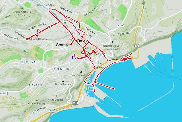
The location this photo was taken from is marked "P" on the cycling route map for that day:


Map and biometrics are generated by the Polar Beat android app using the Polar H10 heart rate monitor.during a permitted Coronavirus lockdown bike ride. Cycling is an approved Covid-19 form of exercise.


Original map and biometrics at this Polar Flow web page.

Abbreviated versions of this post are on Facebook and Twitter.

Monday 27 April 2020

1253 AD St Edmund's Chapel, Priory Road, Dover CT16 1BB, UK

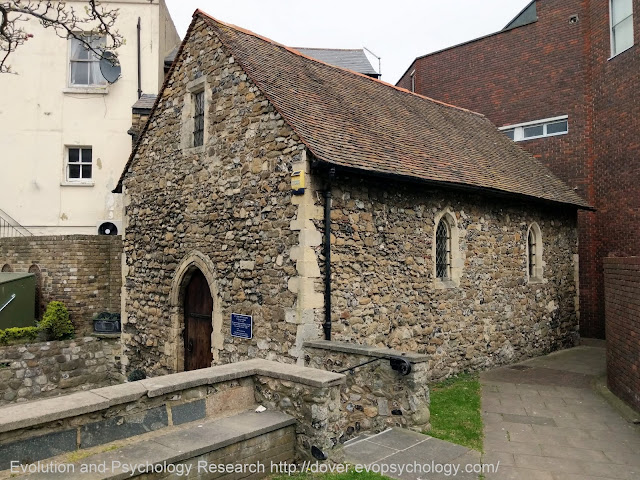
St Edmund's Chapel is probably the smallest church in England still in regular use (1):


Built in 1253 CE. Dedicated by one English saint, St Richard of Chichester, to another English saint, St Edmund of Abingdon.Photo taken on Coronavirus lockdown cycle ride.
The path on the right is "St Edmund's Walk" and leads to the Biggin Street shopping precinct.


Hidden for 400 years, the chapel was restored to public view during the Second World War following a German artillery bombardment in 1943 that demolished two of the surrounding buildings (one of which was "Bicknell's", H. R. Bicknell, a newsagent and tobacconist, also of Priory Road).

This 13th century building, some 28 feet by 14 feet, is the only chapel dedicated by one English saint, St Richard of Chichester, to another English saint, St Edmund of Abingdon (Edmund Rich, or Edmund of Canterbury, consecrated as Archbishop of Canterbury on 2 April 1234):


Saint Richard of Chichester celebrates the Eucharist in St Edmund's Chapel. Located on Priory Road, Dover, Kent, England,. England's smallest chapel in regular use.
Extracted from information plaque: "St Richard celebrates the Eucharist in the Chapel of St Edmund."

St Edmund's Chapel, built in 1253, is now a Listed Building and originally belonged to the Maison Dieu, which ministered to pilgrims, and was under the control of a Master appointed by St Martin's Priory, then the most important institution in the medieval town except for Dover Castle.

A 'Cemetery of the Poor' had been established outside the Priory and the Town Walls, and the chapel was built in its grounds, probably as a Chapel of Rest,

It was consecrated in 1253 by Richard, Bishop of Chichester, in the name of Edmund, a former Archbishop of Canterbury under whom Richard had first studied and who was canonized in 1246:

Richard fell ill and died in the Maison Dieu only 4 days later. Before his body was returned to Chichester Cathedral for burial, his internal organs were removed and buried in a Cist, or pit, under the Chapel altar. This Cist, now empty, can still be seen.

When Richard was canonized in 1262. St Edmund's Chapel became a place of pilgrimage in its own right. It is still the only church in existence that was dedicated to one English Saint by another.

After the Reformation in 1534. the Priory, the Maison Dieu and St Edmunds were forced to close. The chapel was surrendered to King Henry VIII in 1544 (Dissolution of the Monasteries).

Over the years, new buildings concealed the old chapel and its sacred status was forgotten.

It had many uses including, in late Victorian times, use as a blacksmith's forge.

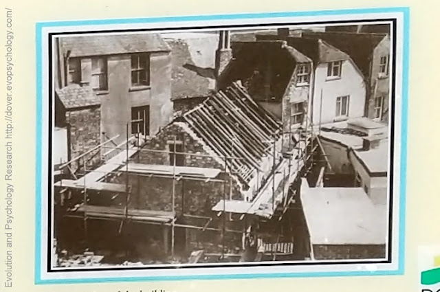
In 1965 Father Tanner, Dover's Roman Catholic Parish Priest, arranged for both the private purchase of the chapel and its restoration, using only genuine medieval materials - at least 75% of the building is original however:


 Father Tanner, Dover's Roman Catholic Parish Priest (St Paul's, Maison Dieu Road) organized the rebuilding of what was once a blacksmith's forge.
Extracted from information plaque: "1965 restoration of the building"


The Chapel was re-consecrated in 1968 and is now owned by a charitable trust who maintain it solely from gifts placed in the wall boxes.

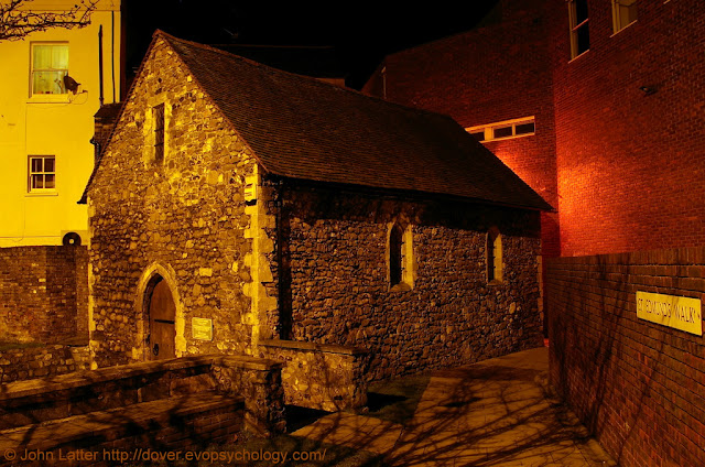
A nighttime photograph of St Edmund's Chapel that was taken on the 8th of January 2011:


Consecrated 1253 by St Richard of Chicester, dedicated to St Edmund of Abingdon. Dissolved 1544; ex-Navy victually store, store room, forge, Toc H Talbot House. Saturday Eucharists. 14 Priory Road. Grade II* Listed Building.


Extract from "The History of the Castle, Town and Port of Dover" by Reverend S. P. H. Statham, Rector of St Mary-in-the-Castle (Longmans, Green, and Co., 1899), page 209:

A Wayside Chapel

    The remains of a very interesting thirteenth century chapel are still to be seen hemmed in by the shops in Biggin Street and Priory Road. It is a small building some twenty-eight feet in length by fourteen broad. 
The walls, which are fairly intact, are built of rubble masonry two feet thick, with Caen stone quoins and dressings. The west doorway is plain pointed with roll mouldings. 
The north and south walls are pierced by two lancet windows each, widely splayed, and a moulded string course ran round the interior below their sills. The roof was of a good pitch, and had tie-beams, collars and struts. 
The chapel is now entirely given up to trade purposes and is difficult of access. 
We conjecture that it was erected by the canons of St. Martin's and St. Mary's Priory, and was used as a wayside chapel, although it is not impossible that it may be the remains of the Hospital of St. Bartholomew's Chapel.

In addition to once being a victualling store for the Royal Navy, a store room, and a blacksmith's forge, prior to the 1965 restoration St Edmund's Chapel was also a Talbot House (Toc H) meeting place.

Internal views of St Edmund's Chapel can be seen in the photo section of the St Edmund Of Abingdon Facebook page.

The main (first) photograph was taken on the 6th of April 2020 during a permitted Coronavirus bike ride.

Covid-19 lockdown: a cycling route map and biometrics can be seen on this Polar Flow web page.

Abridged versions of this post are also on  Facebook and Twitter.

(1) From St Edmund's Chapel

Sunday 26 April 2020

White Cliffs of Dover Rockfall 2012 - 2020, Kent England UK

On the 4th of March 2012, BBC News reported that a large section of Dover's famous white cliffs had broken away and crashed into the English Channel (1)

This zoomed shot of approximately 2.5 miles from St Martin's Battery on the Western Heights shows the western terminator of the landslide as a vertical line running down the center of the photograph:


Modern view of 2012 cliff fall, or landslide at Crab Bay in the English Channel. Langdon Bay and Fan Bay are nearby, as are shipwrecks of the SS Preussen and SS Falcon. Cliff top in this region owned by National Trust.


The "smeared" cliff face to the right of the terminator is an oblique view of the area affected. Note the thin horizontal chalk crevasse on the cliff top above and beyond the top edge of the "smear" but just below the skyline.

The photo was taken about an hour before high tide and consequently it doesn't show the full height or spread of the spoil heap:


Cliff fall, or landslide from above Crab Bay into the English Channel. South Foreland lighthouse and St Margaret's-at-Cliffe are nearby. Crop of image taken with Canon 600D DSLR  and 200mm zoom lens


This section of cliffs is shown in the Rough and Ready White Cliffs of Dover Video (along with a close-up of HM Dover Coastguard station mentioned below) that was filmed at the same time as the main photo was taken.

This next photo has been extracted from the Daily Telegraph video that follows it.

The video was taken soon after the cliff collapsed in 2012 and the image shows the coastline a little  further to the east (ie out of sight of my vantage point at St Martin's Battery):


Image taken from a Daily Telegraph video of 2012 White Cliffs of Dover cliff fall near Crab Bay in the English Channel. Shows adjacent unstable area that could be the next landslide.

The "horizontal chalk crevasse" in the main photo is the top right boundary of the lozenge-shaped area of cliffs that might be where the next substantial cliff fall into the English Channel occurs.

The one-minute Daily Telegraph video, "White cliffs of Dover fall into the sea" (no commentaty):


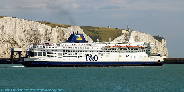
A final photograph taken on the 22nd of July 2010 prior to the rockfall of 2012:


P&O Ferries' MV Pride of Calais ferry in the Eastern Docks of Dover harbour, Kent in 2010. Behind are White Cliffs of Dover at Crab Bay where a cliff fall into the English Channel happened in 2012.


P&O Ferries cross-channel passenger ferry, MS Pride of Calais in front of the Eastern Arm pier and Eastern Docks of Dover harbour (Port of Dover).

On the cliff top behind the ship's funnel is a foreshortened view of the top-left chalk crevasse shown in the video still; the area of the 2012 cliff fall is to its left (nearer the stern of the ship).

MS Pride of Calais was a cross-channel ferry owned and operated by P&O Ferries. She operated the Dover to Calais route between 1987 and 2012.

In early 2013, under bareboat charter to Transeuropa Ferries, she served on their Ramsgate to Ostend route and was re-named MS Ostend Spirit.

After further lay-up in the Port of Tilbury she was sold for scrap and finally beached at a salvage yard in Turkey on 13 November 2013. (3)

The White Cliffs of Dover, part of the North Downs formation, is the region of English coastline facing the Strait of Dover and France.

The cliff face, which reaches a height of 350 feet (110 m), owes its striking appearance to its composition of chalk accented by streaks of black flint.

The cliffs, on both sides of the town of Dover in Kent, stretch for eight miles (13 km). A section of coastline encompassing the cliffs was purchased by the National Trust in 2016. (4)

Also on this blog:


View of chalk cliff and English Channel from A20 roundabout with South Military Road near Archcliffe Fort.
Shakespeare Cliff
Shakespeare Cliff (west of Dover) marks the point where Great Britain most closely approaches continental Europe. On a clear day, the cliffs are easily visible from the French coast.


Photo taken during Covid-19 pandemic lockdown from A2 Jubilee Way. White Cliffs of Dover between the River Dour valley and Broadlees Bottom. Marine Parade (A20) and Athol Terrace. Part of Dover Castle on cliff top.
East Cliff and History
This panorama shows the area of White Cliffs of Dover between the River Dour valley (the town) to the left and Broadlees Bottom (A2 Jubilee Way) to the right.

The post contains close-up of three items of historical interest.

(1) Abridged from White cliffs of Dover section falls into sea:

A large section of Dover's famous white cliffs has broken away and crashed into the Channel, according to the coastguard.

Tonnes of rock collapsed into the sea between Langdon Cliffs and South Foreland Lighthouse.

Dover Coastguard said no-one was injured during the "substantial" rockfall, which happened in an area know locally as Crab Bay.

The National Trust has put up warning signs to alert walkers.

It is thought freezing conditions over the winter may have weakened the chalk cliffs.

(2) The main photograph was taken from St Martin's Battery on the Western Heights on the 24th of April during a permitted Coronavirus bike ride.

(3) Extract from MS Pride of Calais.

(4) Extract from White Cliffs of Dover 

See the Maritime and Coastguard Agency.

Covid-19 lockdown: a cycling route map and biometrics can be seen on this Polar Flow web page.

Abridged versions of this post are also on  Facebook and Twitter.
Saturday 25 April 2020

Superyacht Sherpa 815 in the Port Of Dover, Kent, England UK

Flying the maritime red ensign,  or civil ensign of the Cayman Islands where she is registered, the MY Sherpa is shown departing Dover harbour at 11.48 am on Saturday, 25th of April 2020 en route to Gibraltar:


Support vessel for MY Hamilton II, both Superyachts owned by Jim Ratcliffe, CEO of Ineos. Sherpa is en route to Gibraltar. P&O Ferries MV Spirit of France cross-channel superferry. View from Marina Pier.


Beyond the Southern Breakwater on the left, P&O Ferries' MV Spirit of France RORO passenger ship is on a regular crossing of the English Channel to Calais in France (see below).

The Motor Yacht Sherpa began life as Project 815 in the Royal Dutch Shipyards of Feadship and is often described as a support vessel for the MY Hamilton II although she is a Superyacht in her own right.

Indeed, rather than being a "support" ship, Charter World's Coolest Superyachts around the world suggest that the MY Sherpa was built as a Superyacht for the owner's two sons. 

On this point, both the MY Hamilton II and the MY Sherpa are owned by James Ratcliffe, billionaire CEO of Ineos and reportedly the United Kingdom's richest man.

My step-mother's maiden name was Ratcliffe and I could say that's it's a pity that she wasn't related to him.

However, some residual spark of humanity prevents me from wishing such a fate upon anyone! 😀

This real-time AIS map shows the current position of the Sherpa:


 Click on the "X" in the Sherpa's information banner to see the satellite map behind

The Superyacht Times states:

Created together Cecil Wright & Partners, Project 815 (build name) is the design work of RWD who followed the owner’s brief for an industrial and highly functional exterior that is paired with a detailed interior worthy of the Feadship name.

Inside, features such as a lounge, a dining area and bar are all tucked away beneath the helicopter landing pad aft while accommodation is located in the forward part of the ship.

There is space for seven overnight guests on the main deck in an owner’s suite, two VIP suites as well as four guest cabins.

Marine Traffic MY Sherpa ship information:

IMO: 9795529
Name: SHERPA
Vessel Type - Generic: Pleasure Craft
Vessel Type - Detailed: Pleasure Craft
Status: Active
MMSI: 319139200
Call Sign: ZGHE9
Flag: Cayman Is [KY]
Gross Tonnage: -
Summer DWT: -
Length Overall x Breadth Extreme: 76 x 13 m
Year built: 2018
Also see Yacht and Harbour's Project 815.

This nighttime photo of P&O Ferries' MV Spirit of France (herself often dubbed a "superferry") was taken on the 25th of January, 2013:


Night-time view of P&O Ferries' cross-channel ferry en route to Calais in France. Leaving through the Western Entrance with the Southern Breakwater lighthouse on the left.


The MS Spirit of France has Call Sign: 2DXD5, IMO: 9533816, and MMSI: 235082717; and is sister-ferry to the MS Spirit of Britain.

The lighthouse is the Dover Southern Breakwater West End Light. Hand-held low-light ISO 3200 photo.

To find the Spirit of France's current location (present position) use the search function in the AIS Real-time Map of Ships and Other Vessels, Port of Dover, UK on this blog.

The main photo was taken during a permitted Coronavirus (alt. Covid-19) Lockdown bike ride.

A cycling route map and biometrics can be seen on this Polar Flow web page.

Abridged versions of this post are also on Facebook and Twitter.

Friday 24 April 2020

Rough and Ready White Cliffs of Dover Video, Kent England UK

This one-minute video was filmed from St Martin's Battery on the Western Heights during a permitted Coronavirus Lockdown bike ride on Friday, 24th of April, 2020.

A panoramic landscape that includes zoomed shots of the cliffs and Dover Coastguard station. Final shot shows the Eastern Docks cross-channel ferry terminal and English Channel beyond:


Elsewhere in the video: Dover Castle, Dover harbour (Port of Dover), and the English Channel.

After brief comments on the White Cliffs of Dover, there are photographs showing close-ups of three points of interest in the video: a Victorian print of Langdon Bay, "Space City" (Eastern Docks) at Dawn, and the "twin Towers" of the Coastguard station.


The White Cliffs of Dover 

These cliffs which form part of the British coastline facing the Strait of Dover and France. The cliffs are part of the North Downs formation.

The cliff face, which reaches up to 107 metres (351 ft), owes its striking façade to its composition of chalk (pure white calcium carbonate) accentuated by streaks of black flint.

The cliffs spread east and west from the town of Dover in the county of Kent, an ancient and still important English port.

The cliffs have great symbolic value for Britain because they face towards Continental Europe across the narrowest part of the English Channel, where invasions have historically threatened and against which the cliffs form a symbolic guard.

Because crossing at Dover was the primary route to the continent before air travel, the white line of cliffs also formed the first or last sight of the UK for travelers.

The cliffs are located along the coastline between approximately: Latitude 51°06'N, Longitude 1°14'E and Latitude 51°12'N, Longitude 1°24'E.

View of chalk cliff and English Channel from A20 roundabout with South Military Road near Archcliffe Fort.
Shakespeare Cliff
Shakespeare Cliff (west of Dover) marks the point where Great Britain most closely approaches continental Europe. On a clear day, the cliffs are easily visible from the French coast.

The link on the left contains another of the Victorian prints shown below.

The cliffs are composed mainly of soft, white chalk with a very fine-grained texture, composed primarily of coccoliths, plates of calcium carbonate formed by coccolithophores, single-celled planktonic algae whose skeletal remains sank to the bottom of the ocean and, together with the remains of bottom-living creatures, formed sediments.

Flint, quartz, and iron pyrites ("Fools Gold") are also found in the chalk.

See the National Trust's web page about the White Cliffs of Dover.


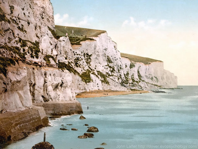
Victorian Colour Photo of the White Cliffs of Dover, Kent UK


One of six photo-mechanical photographs held by the United States Library of Congress. This stretch of cliffs contains Langdon Bay, Crab Bay, and Fan Bay; the SS Preussen and SS Falcon are local shipwrecks.


Derived from a United States Library of Congress photo-mechanical print dated circa 1890-1900 (the above Shakespeare Cliff link has another of these prints)

From the book, The Economy of Kent (Kent History Project):

In 1900 on the White Cliffs of Dover the benefits of American cereals were advertised by two gigantic notices marked 'Quaker Oats'.

Does this photo show one of them on the cliff-top?

This stretch of cliffs contains Langdon Bay, Crab Bay, and Fan Bay; the SS Preussen and SS Falcon are local shipwrecks.


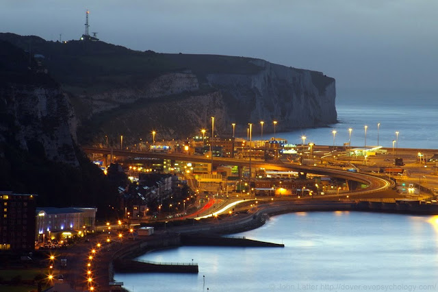
Rain at Dawn for Space City: Eastern Docks of the Port of Dover, Kent


Bounded by the Eastern Armpier, this photo also shows the White Cliffs of Dover with the A" Jubilee Way flyover emanating from Broadlees Bottom. Light trails on the A20. Georgioan houses on East Cliff (Marine Parade).


An 1800-yard zoom photo from St Martin's Battery on the Western Heights of the futuristic Eastern Docks cross-channel ferry terminal of Dover Harbour.

English Channel ferry operators: P&O Ferries and DFDS Seaways.

Shows the A2 Jubilee Way flyover and light trails on the A20 at East Cliff (Marine Parade); Dover Coastguard Station on skyline.

The photo was taken on the 17th of September, 2010.


Twin Towers of HM Dover Coastguard Station from the East, Swingate, UK


Situated on the White Cliffs of Dover overlooking the English Channel. Microwave tower, or mast on the left, radar scanner, or antenna on the right. Low roof of the operations room (control center) is in the middle.


An early morning view of the station at Langdon Battery photographed on Thursday, April the 7th, 2011.

On the right is the Radar Scanner or Antenna. A similar antenna is used by the French Coastguard at the CROSS Gris Nez Rescue Center.

On the left, 70 yards behind the radar tower, is the Microwave Radio Mast whose dishes receive additional radar data from radar sites at Fairlight (near Hastings, East Sussex) and Margate (North Kent).

Between the two towers is the sloping roof of the futuristic-looking Operations Room or Control Room.

There are other buildings and a helipad out-of-shot to the right. There is also a third, smaller mast (tower) on the station, possibly used for gathering meteorological data.

See the Maritime and Coastguard Agency.

Covid-19 lockdown: a cycling route map and biometrics can be seen on this Polar Flow web page.

Abridged versions of this post are also on Facebook and Twitter.

Thursday 23 April 2020

1968 Video: Repairing the White Cliffs of Dover, Kent, UK

A one minute film clip from a British Pathé newsreel showing three workmen suspended in a cradle as they repair unstable areas of the cliff face below Dover Castle and above East Cliff. Three photographs follow the video:


The event was reported elsewhere in the press. I was a boy soldier in the Army Apprentices College at Harrogate at the time and I recall my astonishment at turning a page of the Daily Telegraph and seeing a photograph of Graham Barker, my brother-in-law (see below) working on the cliff face!

This is another still photograph of Graham at Alamy that is available for personal or commercial use only (you can see it at Strengthening the white cliffs). It has the following caption:

9th September, 1968 - Strengthening the white cliffs.: With a fine view of Dover Harbor in the background, Mr. Dennis Smith, 29, of Dover and Mr. Graham Barker (right), 32, of Sheffield, prying loose chalk and flints from the face of the ''White Cliffs'' (nb it might have been clearer if the text said Graham is above Dennis!)

They are undertaking the first stage in an operation to lessen the constant danger of falls caused by erosion and water see page.

Marples Ridgway and Sir William Halcrow and Partners, consultant engineers, under contract to the Ministry of Public Building and Works, are working on about half a mile of the worst affected section, part of the boundary of Dover Castle.

Sixty-four bolts up to 25ft. long have been set in concrete in the cliff face to secure the surface sections to firm bedrock. Each bolt has been checked at the outward end with a Horstman tension meter, a small cylinder of glass which discloses changes in stress when viewed by polarised light.

No changes have been recorded since the bolts were installed a month ago. (Credit Image: Keystone Pictures USA/ZUMAPRESS) 

The first photo is a panorama of the white cliffs below Dover Castle. The workmen were working on the left-hand half of the cliffs above the unseen street of East Cliff:

British Pathe video clip of cliffs below Dover Castle and above East Cliff being repaired in 1968. Graham Barker (my brother-in-law) was one of the workmen). Photo from A2 Jubilee Way shows Marine Parade and Athol Terrace. Eastern Docks cross-channel ferry terminal out of shot to the right.


Photo taken during Covid-19 pandemic lockdown from A2 Jubilee Way. White Cliffs of Dover between the River Dour valley and Broadlees Bottom. Marine Parade (A20) and Athol Terrace. Part of Dover Castle on cliff top.
East Cliff and History
The above photo also appears in a separate post along with close-ups of three points of historical interest. Click on the thumbnail or link to the left.

This next photo shows the street of East Cliff that is obscured in the panorama photo by the Georgian houses of East Cliff (Marine Parade), or more commonly these days, just "Marine Parade":

White Cliffs of Dover above this street were repaired in 1968 and the work recorded in a British Pathé newsreel video clip (alt. British Pathe.). Graham Barker was one of the workmen. East Cliff contains the "First and Last" public house (pub).

These are the houses whose back gardens are shown in the British Pathé (alt. British Pathe) film clip.

This street contains the "First and Last" pub: the first public house to be found after landing in England, and the last public house before sailing from it at the nearby Eastern Docks and cross-channel ferry terminal

Excerpt from the Alamy caption:

"...Mr. Graham Barker (right), 32, of Sheffield..."

Graham did indeed originate from Sheffield, Yorkshire, but at the time the film was made he was living with his wife, Rosalie and two children, Jeanette and Graham (Junior) at 81 Clarendon Place, Dover:

Former home of John Latter (approx 1957 to 1963) and of Rosalie and Graham Barker with their children Jeanette and Graham. Graham senior was living here when he appeared in a 1968 British Pathe newsreel showing him repairing the White cliffs of Dover.

Number 81 is the magnolia coloured house on the left with the antique-looking outside light fixture (photo taken 6th of June, 2009)..

Graham was stationed at Dover Castle in the mid-1950s as a National Service soldier in the York and Lancaster regiment ("York and Lancs").

He met and married my eldest step-sister, Rosalie Higgins and moved into the above house around 1963 or 1964.

Rosalie and Graham now live near Maison Dieu Road in the center of Dover.

Graham's best friend in 1968 was a chap called "Buller" who also appears in the video.

The panorama photo and view of the houses of East Cliff were both taken on the 20th of April, 2020 during a permitted Coronavirus (Covid-19) Lockdown bike ride.

A cycling route map and biometrics can be seen on this Polar Flow web page.

Abridged versions of this post are also on Facebook and Twitter.

Wednesday 22 April 2020

Real-time Map of Ships and Other Vessels, Port of Dover, UK

This is an interactive AIS (Automatic Identification System) map for Dover harbour with a live update feature that auto-refreshes every 600 seconds (10 minutes).

However, the map can be manually refreshed as often as required by clicking on the circular icon at bottom left:


The types of vessel that the map displays are: Cargo Vessels, Tankers, Passenger Vessels, High Speed Craft, Tugs and Special Craft, Fishing, Pleasure Craft, Navigation Aids, and Unspecified Ships.

A further two icons show if a vessel is Underway or Anchored.

Dover is noted for cross-channel ferries and cruise ships but there are no separate categories for these specific type of ships.

Disappointingly, there isn't a Nuclear-Powered Submarine category either.

Clicking on the "coffee filter" icon below the Search symbol at top left on the map shows which colour-coded symbol goes with which type, or category of vessel.

Screenshot:


Selecting, or deselecting the check-boxes of the "Vessel Filters" feature enables any combination of vessel categories to be displayed (the above screenshot has all categories selected).

AIS is intended, primarily, to allow ships to view marine traffic in their area and to be seen by that traffic.

This requires a dedicated VHF AIS transceiver that allows local traffic to be viewed on an AIS enabled chart plotter or computer monitor while transmitting information about the ship itself to other AIS receivers.

Port authorities or other shore-based facilities may be equipped with receivers only, so that they can view the local traffic without the need to transmit their own location.

All AIS transceivers equipped traffic can be viewed this way very reliably but is limited to the VHF range, about 10 to 20 nautical miles.

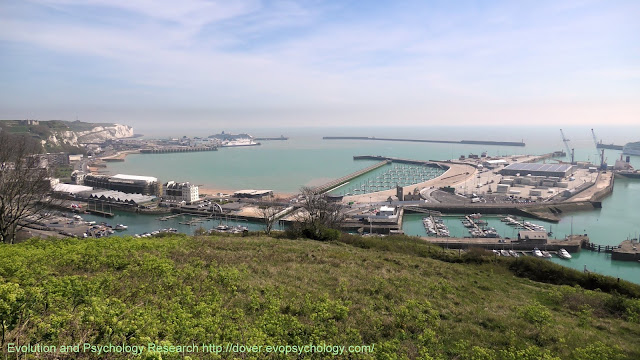
Panorama of Dover Harbour from the Western Heights on the 15th of April, 2020:

View from St Martin's Battery on the Western Heights. Shows White Cliffs of Dover beyond Eastern Docks and Eastern Arm Pier, Southern Breakwater, new Marina pier, Dover Western Docks Revival, part of Admiralty pier, Wellington Dock, Granville Dock and seafront.

The White Cliffs of Dover are beyond the Eastern Docks and Eastern Arm pier on the left.

The English Channel is beyond the Southern Breakwater in the center, and the Dover Western Docks Revival project is right of center.

Wellington Dock and Granville Dock of Dover Marina are behind the seafront and DWDR area.

About the Port of Dover

The Port of Dover is Europe’s busiest ferry port, a vital international gateway for the movement of people and trade.

It is also an award-winning cruise port, the second busiest in the UK and hosts some of the world’s most prestigious cruise lines.

Other successful businesses include a cargo terminal, a top award-winning marina and several niche activities. The business mix is diverse.

Also see Port of Dover  on Wikipedia and Dover Harbour at Dover Museum.

The main photo was taken during a permitted Coronavirus (alt. Covid-19) Lockdown bike ride.

A cycling route map and biometrics can be seen on this Polar Flow web page.

Abridged versions of this post are also on Facebook and Twitter.

Tuesday 21 April 2020

Panorama of the White Cliffs below Dover Castle, Kent, UK

To the left, the White Cliffs of Dover descend to the River Dour valley and the town itself.

To the right, the cliffs dip briefly to a low point called Broadlees Bottom from which the A2 Jubilee Way flyover passes over the Eastern Docks before turning inland and dropping down to the A20 roundabout in the center of the photo:

Photo taken during Covid-19 pandemic lockdown from A2 Jubilee Way. White Cliffs of Dover between the River Dour valley and Broadlees Bottom. Marine Parade (A20) and Athol Terrace. Part of Dover Castle on cliff top.

Today, the cliff-top forms the southern boundary of the grounds of Dover Castle; earlier, it formed the base of an Iron Age Hill Fort.

Graham Barker and two other workmen are shown repairing the White Cliffs of Dover below Dover Castle and above the terrace of houses of East Cliff. A clip from a newsreel that was shown in cinemas. Also reported in the Daily Telegraph newspaper.
Repairing the Cliffs of Dover
Before showing close-ups of three points of historical interest in the above image, there is also a one minute video film clip from a 1968 British Pathé newsreel showing three workmen suspended in a cradle as they repair unstable areas on this part of the cliff face.

One of the workmen is Graham Barker who is my brother-in-law - click the link on the left to have a look.

The first point of interest, left of center, is the concrete platform topped by a white mast that juts out from the cliff edge. This is the Admiralty Lookout and Port War Signal Station:

On edge of White Cliffs in grounds of Dover Castle. Obsolete Hospital Battery of 1874 was converted in 1905 to a Fire Command Post. Admiralty installations added on top in 1914 (WWI) and a concrete roof in 1941 (WWII). Listed Building.

This structure is a Listed Building and had been in a state of dilapidation until it was subject to major conservation and repair carried out over three phases between 2005 and 2008 by the Radley House Partnership (Chartered Architects).

Vice-Admiral Bertram Ramsay's flag flew from this signal station at the start of the Second World War.

The obsolete Hospital Battery of 1874 (contemporary with St Martin's Battery on the Western Heights) was converted in 1905 to a Fire Command Post. Admiralty installations were added on top in 1914 (World War I) and the concrete roof in the photo was added in 1941 (World War II).

The second point of interest is found by following the cliff edge to the left of the signalling station until you come to a v-shaped notch in the vegetation. Immediately below is Casemates Balcony and the cliff entrance to what English Heritage describe as the Secret War Time tunnels:

Vice Admiral Bertram Ramsay was here in 1940 where he planned Operation Dynamo, the evacuation of Dunkirk. Winston Churchill and General Smuts also here during the Second World War. Cliff Casemates Balcony, English Heritage's Secret Wartime Tunnels Entrance. Listed Building.

Calling the chalk excavations, "Secret War Time Tunnels" focusing attention on their role in the Second World War although the tunnels were begun during the Napoleonic Wars (under Colonel Twiss, RE) and continued to be expanded in the Cold War with Russia.

On the left of the Casemates Balcony is a low red-bricked structure with a blocked-up window in front of which Prime Minister Winston Churchill and Field Marshall Jan Smuts (alt. Field Marshal) were photographed during the Second World War.

 Vice-Admiral Bertram Ramsay planned Operation Dynamo, the evacuation of Dunkirk in these tunnels.

The final point of interest is the very left-most house of the Georgian houses of East Cliff (Marine Parade) on the left-hand side of the main photo (those on the right are Athol Terrace).

Built in 1834, Number 8 East Cliff (Marine Parade) is the former home of Charles Lightoller who survived the 1912 RMS Titanic iceberg disaster in the North Atlantic:

Georgian listed building built in 1834. Charles Lightoller moved here in 1916 in the Royal Navy's Dover Patrol, serving on the destroyer HMS Falcon. He once applied for The Spanish Prince which became a blockship in Dover Harbour in 1915.

Elizabeth House is the left-hand third of the Georgian Listed Building. Charles Lightoller moved here after being posted to the Royal Navy's "Dover Patrol" during the First World War and served on HMS Falcon.

Commander Charles Herbert Lightoller DSC & Bar, RD, RNR (March 30, 1874 - December 8, 1952) was the second mate (second officer) on board the RMS Titanic, and the most senior officer to survive the disaster.

Lightoller ("Lights") was decorated for gallantry as a naval officer in World War I and later, in retirement, further distinguished himself in World War II by providing and sailing the Sundowner (one of the "little ships") during the perilous Dunkirk evacuation (Operation Dynamo).

NB There is a single row of modest terraced houses behind East Cliff (Marine Parade) that is known simply as "East Cliff").

The main photo were taken during a permitted Coronavirus (alt. Covid-19) Lockdown bike ride.

A cycling route map and biometrics can be seen on this Polar Flow web page.

Abridged versions of this post are also on Facebook and Twitter.

Monday 20 April 2020

Morrisons Supermarket, Dover: No Queue, No Covid-19, But...

...I did encounter a psychological virus: the "virus" a human being develops when they harden the surface fear of their psychological history, and in so doing, create a psychological weapon with which to damage or distress others.

The background to this aspect of today's visit to my local branch of Morrisons will be described on a sister blog (Dover: The Psychology of a Small Town) and a link provided here once it has been written.

The supermarket is located on Bridge Street, Dover CT16 1RA, and looks across a car park. Along an adjacent side are branches of Asda, Jollyes, Farm Foods, and Poundstretcher, all part of Castleton Retail Park, Charlton Green.

Consequently, this is an important and popular shopping area and queues have been quite lengthy since the Coronavirus Social Distancing rules and reduced opening times came into effect.

However, as you can see from today's photograph (taken at 10 am) all this has changed - at least as far as Morrisons is concerned, anyway!:

Postal address of Morrisons supermarket is Bridge Street, Dover CT16 1RA, Kent, England. Queues that had become familiar during the Coronavirus (Covid-19) Social Distancing and Lockdown rules have disappeared. The reason is that Morrisons have extended their opening times.

Compare the above view to the 11-second video of a Morrisons queue that I posted on this blog on Thursday, 9th of April:


The reason the queue has disappeared is because of a change in opening hours that was announced in an email sent on Saturday, the 18th of April:

From Monday 20th April our store opening hours are:

Monday to Saturday - 7am - 10pm
Sunday - No change


Thank you to our very hard working NHS workers.

We continue to open our stores exclusively for you to shop between 6am - 7am daily (Sunday 9am - 9.30am*).

These opening times are valid in the majority of stores but some may vary, including Scotland - please click here to find your local stores opening times.  


Announces an extension to opening hours that had the immediate effect of reducing the queues due to Social Distancing and the Coronavirus (Covid-19) Pademic.

 Of course, queues are still likely to form at traditionally busy times (Saturday morning, for example) but the shopping experience at Morrisons has definitely improved!

The main photo were taken during a permitted Coronavirus Lockdown bike ride.

A cycling route map and biometrics can be seen on this Polar Flow web page.

Abridged versions of this post are also on Facebook and Twitter.

Sunday 19 April 2020

MV Arcadia Cruise Ship, Port of Dover, 19 April 2020, UK

The P&O Cruises ship, MS Arcadia at Berth C in the Cargo Area of the new Western Docks development of Dover Harbour on Sunday, 19th of April, 2020:

 This P&O Cruises passengher ship is shown backlit at Berth C in the Cargo Area of the new Western Docks development of the Port of Dover. The ship is here because of the Covid-19 Pandemic Lockdown restrictions.

The MV Arcadia arrived in the Port of Dover four days ago and was initially moored alongside the Eastern Arm Pier in the Eastern Docks.

The Eastern Docks are primarily the domain of cross-English Channel ferries but everything is in a state of flux in these days of  Coronavirus Lockdown restrictions!

Video still of the P&O Cruises passenger ship entering the English Channel through the Western Docks of Dover Harbour.
MS Arcadia video link
Yesterday, the MV Arcadia ventured out into the English Channel and returned just before 4 am this morning.

Her departure through the Western Entrance, behind the ship in the above backlit photo, was recorded in the one-minute video shown in yesterday's blog post (click on the thumbnail to the left).

The MS Arcadia entered service in 2005 and is registered in Hamilton Bermuda. More information on her history and ship's details (eg Call sign: ZCDN2, IMO number: 9226906, MMSI number: 310459000) is also available at the thumbnail link.

This real-time AIS map shows the current position of the Arcadia:


 Click on the "X" in the Arcadia's information banner to see the satellite map behind

A final photograph is a close-up the stern decks of the Arcadia:

The Covid19 Pandemic has currently caused P&O Cruises to cancel all scheduled cruises. The Arcadia has no passengers aboard.

With her stern pointing towards the shore, there would usually be a number of passengers visible, talking to one another and occasionally taking photos and videos of visible local landmarks such as Shakespeare Cliff, Dover Castle, and the White Cliffs of Dover.

However, the Covid-19 Pandemic means the ship is empty of passengers. Let's hope they are able to return soon!

The photos were taken during a permitted Coronavirus Lockdown bike ride.

A cycling route map and biometrics can be seen on this Polar Flow web page.

Abridged versions of this post are also on Facebook and Twitter.
Saturday 18 April 2020

Arcadia Cruise Ship Video, Port of Dover, 18 April 2020, UK

The P&O Cruises ship, MS Arcadia entering the English Channel through the Western Entrance of Dover harbour (Port of Dover) after arriving here from Southanpton three days ago.

The Southern Breakwater is on the left and Admiralty Pier on the right.

There are no passengers on board the MS Arcadia, of course, because of the Coronavirus Pandemic Lockdown:


The Arcadia returned to Dover just before 4 am the following day (Sunday, 19th of April, 2020).

This P&O Cruises passengher ship is shown backlit at Berth C in the Cargo Area of the new Western Docks development of the Port of Dover. The ship is here because of the Covid-19 Pandemic Lockdown restrictions.
MS Arcadia at Berth C
Instead of returning to the Eastern Arm Pier where she had previously been berthed, the ship moored at Berth C in the Cargo Area of the new Western Docks development.

Two photos of the passenger ship in her new position (taken from the Marina Pier) can be seen by clicking on the thumbnail to the left.

MV Arcadia was ordered by Holland America Line in 2000 as their fifth Vista-class vessel.

In 2003 she was allocated to Cunard Line to become their Queen Victoria.

Shortly before her launch the decision was made to transfer the ship to the P&O Cruises fleet. As a result, Arcadia has a Cunard-style mast similar to those found on RMS Queen Elizabeth 2 and RMS Queen Mary 2.

She also sports a modified Queen Elizabeth 2-style funnel, with cowling removed instead of the traditional P&O style funnel found on the purpose-built Oriana and Aurora.

The passenger ship Arcadia, along with Oriana, are adult-only ships. This real-time AIS map shows her current position:


 Click on the "X" in the Arcadia's information banner to see the satellite map behind

Ship Details:

Name:    Arcadia
Namesake:    The region of Arcadia (Greece)
Owner:    Carnival plc
Operator:    P&O Cruises

Identification:

    Call sign: ZCDN2
    IMO number: 9226906
    MMSI number: 310459000

Port of registry:     Hamilton, Bermuda
Ordered:    2000
Builder:    Fincantieri (Porto Marghera, Italy)

Cost:    USD 400 million
Yard number:    6078
Laid down:    12 July 2003
Launched:    26 June 2004
Acquired:    29 March 2005
In service:    April 2005

Status:    In service

The video was made during a permitted Covid-19 Lockdown bike ride.

A cycling route map and biometrics can be seen on this Polar Flow web page.

Abridged versions of this post are also on Facebook and Twitter.

Source: MV Arcadia

Friday 17 April 2020

Constable's Gate and Queen Mary's Tower, Dover Castle, UK

Constable's Gate (alt. Constable's Tower) is partially obscured by the d-type Queen Mary's Tower (the curved structure right of center with truncated triangular base) that stands 20 yards nearer to the viewer than the gateway itself.

Contents

1) Main photo of Constable's Gate and Queen Mary's Tower

2) Victorian print of Constable's Gate seen from the other side.

3) Similar view as the Victorian print but taken in 2011.


Dover Castle is owned by English Heritage and is a scheduled Ancient Monument; it contains structures such as the Roman Pharos that are Listed Buildings in their own right.


1) Main photo of Constable's Gate and Queen Mary's Tower


Western Outer Curtain Wall on right; drawbbridge on left. English Heritage and Ancient Monument. View from Marina Pier in Dover harbour.

The Western Outer Curtain Wall comes in from the right of the photograph to Queen Mary's Tower, and then continues on to Constable's Gate on its far side.

Any view of Queen Mary's Tower is relatively rare because it stands within the walled garden of the gateway, the traditional home of the Deputy Constable of Dover Castle.

This view is even "rarer" than most because it is a zoomed shot of about 1500 yards taken from the New Marina Pier in Dover harbour that until recently did not exist - and, of course, because it was taken during a permitted Coronavirus Lockdown bike ride.

Constable's Gateway is today's pedestrian entrance into Dover Castle via the drawbridge on the left.

The castle itself is what Matthew Paris, a Benedictine monk and English chronicler, once famously described as the Lock and Key to the Kingdom of England.

Constable's Tower was built by John de Fiennes under William the Conqueror and for this reason was once known as Fiennes' Tower.

In 1216, during the Great Siege of Dover Castle in the First Barons' War against King John, the Dauphin (Prince Louis, later Louis VIII of France, son and heir apparent of Philip Augustus) unsuccessfully besieged Dover Castle.

The importance of Dover Castle to the Dauphin's campaign is reflected in this excerpt from "The antiquities of England and Wales" (by Francis Grose, published 1784):

When Lewis the Dauphin of France came hither, at the instigation of the pope, and by the invitation of the barons, and had made himself master of most of the castles in the southern counties, his father, hearing that he had not got possession of Dover Castle, swore by St. James's arm, he had not gained a foot of land in England.

Despite the failure to take Dover Castle, Prince Louis' miners so damaged the Northern Entrance (North Gate) that it had to be closed and sealed.

In the 1220s, Hubert de Burgh then rebuilt Constable's Tower as an alternative entry point which probably led to it being called by its other name of Newgate Tower.

Constable's Gateway was modernized in 1882, and as satated above, is the quarters of the Deputy Constable of Dover Castle, who at one time was the commanding officer of any Dover-based battalion but is now the senior military officer for the district.

From "The History of the Castle, Town and Port of Dover" by Reverend S. P. H. Statham, Rector of St Mary-in-the-Castle:

See: St Mary-in-Castro
Port Tower (Porth Tower) has been known under various names, Laswells Tower (Laswell's Tower), Gostling Tower or Queen Mary's Tower. 

It was supported by the Manor of Dane in Sussex, according to Sir Edward Bering, but it is more probable that the manor of Laswell in Kent was set aside for this purpose. Otherwise one of its names loses all significance. 

Gostling seems to have been the name of one of the knights who held this manor on military tenure, and so gave his name to the tower. It felt down in the reign of Edward VI, and was rebuilt by Queen Mary (Mary I or Mary Tudor), after whom it was consequently named. 

It seems to have been used as an office before its ruin. (Published by Longmans, Green, and Company, 1899) (abridged).

Out of shot to the right, the Western Outer Curtain Wall follows the outline of an Iron Age Hill Fort.


2) Victorian print of Constable's Gate seen from the other side.


Constable's Tower built by William the Conqueror. Rebuilt as Constable's Gateway, Newgate, by Henry III. 1869 illustration or engraving, possibly by S or G Winebridge, printed W. W. Sprague and Co., London. English Heritage Listed Building.

The "classic view" of Constable's Gate as seen from Constable's Road near its junction with Castle Hill Road.

This 1869 illustration or engraving, possibly by S or G Winebridge (the lettering is indistinct) was printed W. W. Sprague and Company, London, England.


 3) Similar view as the Victorian print but taken in 2011


A more modern classic view of Constable's Gate, taken by myself on the 20th of May, 2011.

A cycling route map and biometrics during which I took the first photo can be seen on this Polar Flow web page.

Abridged versions of this post are also on Facebook and Twitter.