This is an interactive AIS (Automatic Identification System) map for
Dover harbour with a live update feature that auto-refreshes every 600
seconds (10 minutes).
However, the map can be manually refreshed as often as required by clicking on the circular icon at bottom left:
The types of vessel that the map displays are: Cargo Vessels, Tankers,
Passenger Vessels, High Speed Craft, Tugs and Special Craft, Fishing,
Pleasure Craft, Navigation Aids, and Unspecified Ships.
A further two icons show if a vessel is Underway or Anchored.
Dover is noted for cross-channel ferries and cruise ships but there are no separate categories for these specific type of ships.
Disappointingly, there isn't a Nuclear-Powered Submarine category either.
Clicking on the "coffee filter" icon below the Search symbol at top left
on the map shows which colour-coded symbol goes with which type, or category of
vessel.
Screenshot:
Selecting, or deselecting the check-boxes of the "Vessel Filters"
feature enables any combination of vessel categories to
be displayed (the above screenshot has all categories selected).
AIS is intended, primarily, to allow ships to view marine traffic in
their area and to be seen by that traffic.
This requires a dedicated VHF
AIS transceiver that allows local traffic to be viewed on an AIS
enabled chart plotter or computer monitor while transmitting information
about the ship itself to other AIS receivers.
Port authorities or other
shore-based facilities may be equipped with receivers only, so that they
can view the local traffic without the need to transmit their own
location.
All AIS transceivers equipped traffic can be viewed this way
very reliably but is limited to the VHF range, about 10 to 20 nautical
miles.
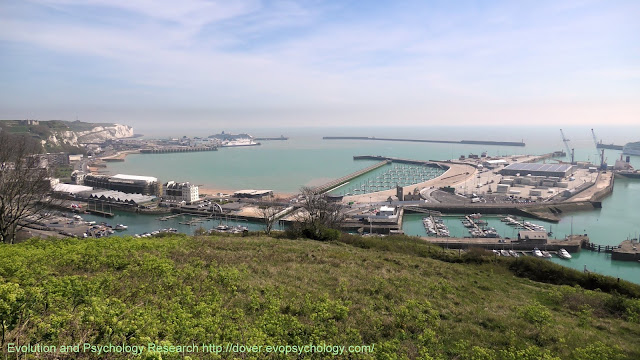
Panorama of Dover Harbour from the Western Heights on the 15th of April, 2020:
The White Cliffs of Dover are beyond the Eastern Docks and Eastern Arm pier on the left.
The English Channel is beyond the Southern Breakwater in the center, and the Dover Western Docks Revival project is right of center.
Wellington Dock and Granville Dock of Dover Marina are behind the seafront and DWDR area.
About the Port of Dover
The Port of Dover is Europe’s busiest ferry port, a vital international gateway for the movement of people and trade.
It is also an award-winning cruise port, the second busiest in the UK
and hosts some of the world’s most prestigious cruise lines.
Other
successful businesses include a cargo terminal, a top award-winning
marina and several niche activities. The business mix is diverse.
Also see Port of Dover on Wikipedia and Dover Harbour at Dover Museum.
The main photo was taken during a permitted Coronavirus (alt. Covid-19) Lockdown bike ride.
A cycling route map and biometrics can be seen on this Polar Flow web page.
Abridged versions of this post are also on Facebook and Twitter.


No comments:
Post a Comment