Showing posts with label port of dover. Show all posts

Tuesday, 19 May 2020

MS Disney Magic Cruise Ship, Port of Dover, Kent, England UK

This video of the MS Disney Magic in Dover was taken on the 2nd of June 2020 and added to this blog post on the 4th:


Original post:

A zoomed snapshot of 900 yards showing Disney Cruise Line's MV Disney Magic passenger cruise ship soon after her arrival in the Port of Dover, Kent, England on Tuesday, 19th of May, 2020:


Disney Cruise Line's passenger ship arrival during Coronavirus lock down restrictions May 19th, 2020. Vessel berthed at Cruise Terminalo One (CT1) on Admiralty Pier in Dover Western Docks Revival area of the harbour. Old Customs House shown. Viewfrom A20 Limekiln Street.
View from A20 Limekiln Street across Crosswall Quay to the MV Disney Magic.

The ship wasn't carrying any passengers because of the Coronavirus pandemic on cruise ships and the travel restrictions that were subsequently imposed.

However, the MS Disney Magic entered Dover harbour with crew members from the MS Disney Fantasy and the MS Disney Dream on board who are presumably awaiting repatriation.

Before proceeding to the live-update map of the MS Disney Magic's current position, and photographs of her during a pre-Covid-19 visit to Dover, note the green copper cupola projecting above the ship's stern:


Old Customs Watch House with green copper observation dome (cupola, belvedere) built 1909-1911 by architect, Arthur Beresford Pite. Listed Building. Inner Harbour; Tidal Harbour, Dover Marina (right). View: North Pier (hoverport). Kent.
Customs Watch House, South Pier.
This is the top of the Old Customs Watch House that was designed by architect Arthur Beresford Pite and built between 1909 and 1911.

Customs and Excise officers from here went to the nearby Lord Warden Hotel (blog post) to interview Louis Bleriot (blog post) after the first flight across the English Channel in 1909.

The MS Disney Magic's current location is shown on this A.I.S ("Automatic Identification System") map:


The day after the first photo was taken, the MS Disney Magic moved to the cargo area of the Dover Western Docks Revival, thereby enabling this photo of Goofy on the ship's stern to be taken on the 21st of May:


Figure of the Walt Disney cartoon character, Goofy, on the stern of the Disney Magic passenger cruise ship in the Port of Dover, UK. Ship was built in Italy and entered service in 1998. In Dover harbour during Coronavirus pandemic, Covid-19 travel restrictions.


And this is how Walt Disney's Goofy looked on the 6th of July, 2010, viewed from the Admiralty Pier with the White Cliffs of Dover (blog video) in the background:


Cruise Ship IMO: 9126807, Call Sign: C6PT7. Stockholm (Sweden to Oslo (Norway). Operator: Disney Cruise Line. At Cruise Terminal 2 (CT2), Admiralty Pier, Western Docks. Also Prince of Wales Pier and Cafe; Eastern Docks. Port of Dover, Kent, England.

:
'S funny how Goofy never seems to age... (😀)


Photos from the cruise ship's earlier visits to the Port of Dover:


The MS Disney Magic manoeuvering in the Western Entrance of Dover harbour on the 12th of June, 2010:


Owner: Disney Cruise Line. From Lisbon (Portugal), going to Oslo (Norway). Call Sign, C6PT7. IMO, 9126807. View from Prince of Wales Pier. English Channel on left, Admiralty Pier right. The passenger ship is reversing from the Western Entrance towards the Admiralty Pier.


The MS Disney Magic, berthed against the Admiralty Pier of the Western Docks, and the Waasland Sea Barge, in port to remove the SS Spanish Prince WW1 block ship, on the 24th of June, 2010:


Disney Magic cruise ship from Stockholm (Sweden) to Oslo (Norway). Waasland in Dover to remove wreck of Spanish Prince, World War I blockship. View from Prince of Wales Pier of Cruise Terminal 2 (CT2), Admiralty Pier, Western Docks.


From the MS Disney Magic's homepage:

Created with your entire family in mind, the Disney Magic combines classic nostalgia and modern amenities with Disney’s signature service.

Step aboard for spacious staterooms that ensure everyone’s comfort.

Get lost in original Broadway-quality entertainment. Indulge in first-rate dining.

From bow to stern, set sail for unforgettable storytelling that only Disney could bring to life.

Ship's data (as of 2010):

Name: Disney Magic

Owner: Disney Cruise Line

Operator: Disney Cruise Line

Port of registry: Nassau, Bahamas

Builder: Fincantieri Marghera shipyard, Italy

Maiden voyage: July 30, 1998

In service: 1998

Status: In active service, as of 2010

Type: Cruise ship

Tonnage: 83,000 gross register tons (GRT)

Length: 964 ft (294 m)

Beam: 106 ft (32 m)

Draft: 25.3 ft (7.7 m)

Decks: 11

Speed: Cruising 21.5-knot (39.8 km/h), maximum 24 kn (44 km/h)

Capacity: 2,400 passengers

Crew: 945

Call Sign: C6PT7

IMO: 9126807

MMSI: 308516000

Covid-19 exercising: cycling route map and biometrics are on this Polar Flow web page.

Abridged versions of this post are also on Facebook and Twitter.

Friday, 15 May 2020

Saga of the Lost Covid-19 DIY PPE Face Mask, Dover, Kent, UK

Not overly confident with needle and thread, I had been inordinately pleased with a DIY PPE Coronavirus face mask that I made using a handkerchief, stapler, and an odd length of elastic.

Then, some four days later, on Friday the 15th of May, 2020, I arrived home from a shopping trip and shortly afterwards realized that my face mask was 'gone'.

This "rough and ready" video details the steps I took until the face mask and myself were (happily) reunited:


A (very) minor example of how perseverance can triumph over adversity!

As a 69 year-old pensioner, the video also illustrates the general principle of exploring all possible internal and external avenues whenever something unexpected, or unwelcome occurs in life, and then, irrespective of whatever the experience or outcome may have been, "moving on".

An approach that doesn't accumulate any psychological baggage! (Note 1)

Before I digress too far, here are some photos of the face mask and  notes on its construction.

A  Covid-19 D.I.Y. Personal Protective Equipment (PPE) face mask, Mark 1 (altered to Mark 1A in the final photograph):


Basic Materials:


Materials, or components required are a mans handkerchief, a stapler (staple gun), and two equally long pieces of elastic of a suitable length for their purpose. All purchased from Dover, UK charity shops (thrift shops)


The box of three James Pringle mens handkerchiefs, stapler (staple gun), and bag of mixed lengths of elastic had been purchased at different times from various charity shops (thrift shops) in Dover, England.

Front view:


A view from the front, demonstrating how the staples go through all layers of the folded handerchief before attaching the two elastic ear loops. Full construction details are given on the Dover Coronavirus Lockdown Blog UK web page, Saga of the Lost Covid-19 DIY Face Mask, Dover, Kent, UK.


In the Mark II version, I'm going to attach the bottom ends of the elastic ear flaps further down the sides of the mask.

Note the "designer" folds at the bottom corners 😀 (actually intended to add a little weight so that the mask hangs closer to the face - a consideration for someone who has a nose as big as mine!)

Rear view:


Rear view shows how the staples bridge both ends of the folded handerchief and go through all 8 layers of the cotton mask. Full construction details are given on the Dover Coronavirus Lockdown Blog UK web page, Saga of the Lost Covid-19 DIY Face Mask, Dover, Kent, UK.


Construction details of the homemade mask:

1) Fold the handkerchief twice length-ways so that you now have four layers of material.

2) Fold the short ends of the rectangle inwards until they meet in the middle as shown.

3) Staple across the folded ends so that the staples go through all eight layers of cotton.

4) "Double staple" the  ends of the elastic loops to the mask for durability.


A still from the Friday, 15th of May video:


Homemade Personal Protection Equipment (P.P.E.) face mask made with a handkerchief, staples, and two elastic ear loops. The harbour, Dover Castle and iconic White Cliffs are in the background. Photo taken on a cycling ride during the Coronavirus pandemic


Wearing the homemade face mask at the end of the New Marina Pier in the Dover Western Docks Revival (DWDR) area of the Port of Dover. The famous white cliffs and castle are in the background.


The Mark 1A revision (made on Sunday, 17th of May):


John Latter on the New Marina Pier, Dover Western Docks Revival (DWDR) area of the Port of Dover, Kent, England, wearing a homemade Coronavirus personal protection equipment face mask. Dover Castle's Saxon St Mary-in-Castro church and Roman Pharos on the White Cliffs in background.


I decided to alter the bottom of the mask (using staples, of course) to better follow the contours of my amazingly manly lower jaw.

Once I had done so, I donned the mask and looked in a mirror and was very impressed with the results (more so than the above selfie might appear to warrant!)

However, I have since been plagued by vague but persistent impulses to either operate on people (à la Mathew Gee, a brilliant surgeon) or eat them (à la Hannibal Lector, a less than brilliant psychiatrist).

Watch this space... (or the news 😀)

Cycling route map and biometrics are on this Polar Flow web page.

Abridged versions of this post are also on Facebook and Twitter

Note 1:

In terms of "grumpiness", negativity, viciousness, and malicious gossip, all of which are of unnatural (i.e. of psychological) origin, and symptomatic of a deeper malaise, I've met "pensioners" who are barely out of their teens - and some who have not yet reached them.

And when something unexpected or unwelcome happens in the lives of such people, someone has to pay...

John Latter

Dover Blog - The Psychology of a Small Town

Thursday, 14 May 2020

2/2 First Covid-19 Lockdown Cycle Ride, Dover Seafront, UK

A permitted Coronavirus cycle ride along the promenade from the Eastern Docks to the New Marina Pier, Port of Dover, Kent, England, UK.

After the video there are close-ups of numbers 11 to 20 of the mainly historical local landmarks that are mentioned in the commentary.

The previous post, 1/2 First Covid-19 Lockdown Cycle Ride, contains close-ups of landmarks 1 to 10 (nb "First" in both titles indicates that I'll be making another video of the same route):


The video was filmed on Sunday, 10th of May 2020, using a head-mounted GoPro Hero 8 Black action camera and its built-in microphones.


Entrance to what was once a builder's yard in Tower Hamlets at 13 West Street, CT17 0DU, Dover, England. This is where I live and do private research into Evolution (Internal Evolutionary Mechanism), Psychology (The Archeotrauma, Trauma), and aspeccts of Social Psychology.
Time Lapse Video Start

Two days later I made a three-minute GoPro "Time Warp" (time lapse) video with commentary.

It contains a sequence that also shows the promenade from the Eastern Docks to the New Marina Pier.

Local landmarks, numbers 11 to 20:

Click on a thumbnail for a larger view, or any text link to go to the related blog post.


Victorian Waterloo Crescent Grade II Listed Building. Marine Parade. DHB's Harbour House. Best Western Dover Marina Hotel and Spa, ex-Churchill Hotel, White Cliffs Hotel (Eisenhower and Churchill in WW2), part of ex-Shalimar Hotel right. Royal Cinque Ports Yacht Club.
White Cliffs Hotel at Sunrise
Former White Cliffs Hotel, Waterloo Crescent

Where Prime Minister Churchill and President Eisenhower had dinner during the Second World War.

Now the Best Western Dover Marina Hotel and Spa.

Fairbairn Crane pre-restoration (2011)
Fairbairn Crane

Swan-neck tubular crane of 1868 on Esplanade Quay, ex-Ordnance Quay of Wellington Dock.

There's a working steam-powered version in Briatol

A Grade II Listed Building.

Triple spiral staircase linking Grand Shaft Barracks to Snargate Street. Built on Western Heights 1805-1807 in Napoleonic Wars. Lieutenant (Quartermaster) Charles Wooden, Victoria Cross, died in barracks above in 1876; he rode in Charge of the Light Brigade, Balaclava, Crimean War, 1854.
Grand Shaft, Pentax K100D  (2011)
The Grand Shaft

Triple spiral staircase built during the Napoleonic Wars.

Linked the Grand Shaft Barracks on top of the Western Heights cliffs to Snargate Street below.

Keep built 12th Century by Henry II's Norman architect, Maurice the Engineer (mason), with corner towers and pilaster buttress. English Heritage, Listed building. Medieval Royal Palace of King's Hall, King's Chamber, Guest Hall, and Guest Chamber. View from King's Gateway.
View of the Keep from King's Gate
The Keep, or Great Tower of Dover Castle

Built in AD 1180's by Maurice the Engineer for King Henry II

Contains reconstructed medieval royal palace.

English Heritage Listed Building and Ancient Monument.

Pharos lighthouse built 46 AD, Emperor Claudius, Aulus Plautius governor. Bredenstone: Western Heights. Once St Mary-in-Castro belfry, King Lucius Church. Restored: Gilbert Scott, William Butterfield. Garrison School. Officers New Barracks or Officers Mess. Fire Beacon, English Channel.
St Mary-sub-Castro and Pharos
Saxon St Mary-in-Castro Church and Roman Pharos

Church is 10th century AD, restored by the Victorians.

Lighthouse built AD 46, reign of Emperor Claudius.

Both lie in grounds of Norman 12th century Dover Castle.

Situated on the White Cliffs of Dover overlooking the English Channel. Microwave tower, or mast on the left, radar scanner, or antenna on the right. Low roof of the operations room (control center) is in the middle.
HM Coastguard Station, Dover
HM Coast Guard Station Dover

Located at Langdon Battery, Swingate, on the White Cliffs of Dover overlooking the English Channel.

Two masts of Second World War Swingate Chain Home Radar Station, ex-RAF Swingate, now Swingate Transmitting Station. Also: Coastguard Cottages, Broadlees Bottom, A2 Jubilee Way bypass, White Cliffs of Dover, Eastern Docks, Dover harbour from Prince of Wales pier.
A2 Jubilee Way, Eastern Docks
A2 Jubilee Way Flyover

From Broadlees Bottom, low point in the White Cliffs of Dover, to the Eastern Docks.

Also World War Two Swingate radar masts and former Coast Guard Cottages.

Cross-Channel ferries in front of Eastern Arm pier with Eastern Entrance and English Channel on the right. Owner: P&O Ferries. Route: Dover to Calais (France). MS Spirit of France (departing, left). MS Pride of Canterbury (arriving, right). Port of Dover, DFDS Ferries also an operator.
In front of Eastern Arm pier (2012)
Cross-Channel Ferries

P&O Ferries' MV Spirit of France is on the left and MV Pride of Canterbury is on the right.

DFDS Ferries also operates from the Eastern Docks.

Holland America Line. From Copenhagen (Denmark), going to Amsterdam (Netherlands). Call sign PFRO, IMO 8919257. Southern Breakwater, Western Docks. Also: Western Entrance, Dover Breakwater West End Light, Admiralty Pier Lighthouse. Kent, England.
MV Maasdam, Holland America Line
Western Entrance of Dover Harbour

Southern Breakwater on the left, Admiralty Pier on the right.

Lighthouses undergoing restoration in 2010.

Prince of Wales Pier Light was built 1902. 46 feet high stone tower. Very quick flashing green light VQ, 100+ flashes per minute. Cafe behind lighthouse. Gateway Flats on seafront. Taken from above Cruise Terminal 3, Admiralty Pier, Dover Western Docks Revival.
POW Pier Lighthouse in 2010.
Prince of Wales Pier Lighthouse 

Built 1902. 46 feet high stone tower.

Very quick flashing green light VQ, 100+ flashes per minute.

Cycling route map and biometrics are on this Polar Flow web page.

Abridged versions of this post are also on Facebook and Twitter.

Wednesday, 13 May 2020

GoPro Hero 8 Timewarp Cycle Video, Urban Coast, Dover, UK

A first attempt (with commentary) at a time lapse video made on Tuesday, 12th of May 2020 - the last day of full Coronavirus Lockdown restrictions as they applied to exercise in England:


All I did was select "Time Warp", the resolution, a linear lens aperture (as opposed to "fish-eye"), and then pressed  the "Start" and "Stop" buttons on my GoPro Hero 8 Black action camera as and when necessary.

Every other setting was selected by the camera's software (I may start messing about with the controls before making another time lapse video, but quite frankly, there just aren't enough hours in the day!)

The video's resolution is 1080p at 30 frames per second. It is 3 minutes long and took over 8 hours to upload to YouTube.

I would shoot 1080p at 60fps, 2.7K or even 4K, if it wasn't for the upload time overhead (plus my clockwork computer isn't exactly sympathetic towards video editing).

Nevertheless, I'm still very pleased with the results 😀

Cycling from the Eastern Docks along the seafront promenade above the pebble beach to the New Marina Pier of Dover Western Docks Revival (DWDR). ommentary identifies 20 local landmarks, mostly of historical interest. Filmed using a GoPro Hero 8 Black action camera.
First Seafront Cycling Video
A conventional video of a bike ride along the seafront promenade between the Eastern Docks and New Marina Pier identifies 20, mostly historical, local landmarks.

The time warp video route map (of what has become my "standard" daily bike ride) was plotted by a Polar Beat smartphone app in conjunction with a Polar H10 heart rate monitor (review):


A GoPro Hero 8 Black, Time Warp" video made on 12th of May, 2020 - last day of full Covid-19, or Coronavirus Lockdown restrictions applicable to England.  6 Robsons Yard (Tower Hamlets) to Buckland Bridge, Eastern Docks, Dover Western Docks Revival (DWDR) and back.


Outward Route:


Entrance to Robsons Yards Flats, 13 West Street, Dover, Kent, England. Where I (John Latter) do private research into Evolution (a testable Internal Evolutionary Mechanism), Psychology (The Archaeotrauma, Trauma), and Social Psychology. Southern Housing Group.
1-6 Robsons Yard Flats, Tower Hamlets, Dover in 2009.

6 Robsons Yard, West Street, East Street, Tower Hamlets Road, De Burgh Street, Templar Street, London Road, Buckland Bridege.

Buckland Avenue, Barton Road, Frith Road, Salisbury Road, Albert Road, Maison Dieu Road, Woolcomber Street.

A20 Townwall Street, East Cliff, Athol Terrace, East Cliff (Marine Parade).

Dover seafront promenade from the Eastern Docks to the New Marina Pier (Dover Western Docks Revival, DWDR).

Return Route:


A20 Limekiln Street goes to Snargate Street, Townwall Street, and Eastern Docks. Archliffe Road goes to Folkestone. The Viaduct Flyover goes to Admiralty Pier; Elizabeth Street, Bulwark Street, and Hawkesbury Street. Car Wash. Near Port of Dover. Night photography.
Light Trails on Limekiln Roundabout at Night (2010)


New Marina Pier to the Esplanade, Union Street, A20 Limekiln Street to Likekiln Roundabout (that I called Limehouse Roundabout in the video!).

Limekiln Roundabout, Limekiln Stret, Prince of Wales Roundabout, Snargate Street, York Street Roundabout.

York Street, Folkestone Road Roundabout, Folkestone Road, Priory Station Approach Road, Dover Priory Rail Station, Dover Priory Roundabout.

Priory Station Approach Road, Folkestone Road, Folkestone Road Roundabout, Priory Street, High Street.

Tower Hamlets Road, East Street, West Street, 6 Robsons Yard.

Original route map and biometrics (after I remembered to connect my heart rate monitor!) are on this Polar Flow web page.

Abridged versions of this post are also on Facebook and Twitter.
 

Monday, 11 May 2020

1/2 First Covid-19 Lockdown Cycle Ride, Dover Seafront, UK

A permitted Coronavirus cycle ride along the promenade from the Eastern Docks to the New Marina Pier, Port of Dover, Kent, England, UK.

After the video there are close-ups of numbers 1 to 10 of the mainly historical local landmarks that are mentioned in the commentary.

A second post, 2/2 First Covid-19 Lockdown Cycle Ride, contains close-ups of landmarks 11 to 20 (nb "First" in both titles indicates that I'll be making another video of the same route):


The video was filmed on Sunday, 10th of May 2020, using a head-mounted GoPro Hero 8 Black action camera and its built-in microphones.


Entrance to what was once a builder's yard in Tower Hamlets at 13 West Street, CT17 0DU, Dover, England. This is where I live and do private research into Evolution (Internal Evolutionary Mechanism), Psychology (The Archeotrauma, Trauma), and aspeccts of Social Psychology.
Time Lapse Video Start

Two days later I made a three-minute GoPro "Time Warp" (time lapse) video with commentary.

It contains a sequence that also shows the promenade from the Eastern Docks to the New Marina Pier.

Local landmarks, numbers 1 to 10:

Click on a thumbnail for a larger view, or any text link to go to the related blog post.


Georgian listed building built in 1834. Charles Lightoller moved here in 1916 in the Royal Navy's Dover Patrol, serving on the destroyer HMS Falcon. He once applied for The Spanish Prince which became a blockship in Dover Harbour in 1915.
Charles Lightoller in Dover
8 East Cliff, Marine Parade

Former home of Charles Lightoller, survivor of the 1912 RMS Titanic iceberg disaster.

Moved here in 1916 during World War One after joining the Dover Patrol.

Born 1824, educated King's School Canterbury, entered Bengal Artillery 1842. Transferred Royal Artillery after Indian Mutiny 1857. Married 1863. Made Knight Commander Order of the Bath, Queen Victoria's Diamond Jubilee 1897, died 1 East Cliff 1899.
1 East Cliff (Marine Parade), Dover
1 East Cliff, Marine Parade

Former home of General Sir Henry Le Geyt Bruce, Knight Commander of the Bath, 1824-1899.

Transferred from Bengal Artillery to Royal Artillery after 1857 Indian Mutiny.

Seaplane Station

First World War RAF or RFC squadron location.


The Mote, or Moat's Bulwark artillery battery has a semi-circular lower level or gun platform and an upper level terrace containing the West Gatehouse or Guardroon ruins. Built by King Henry VIII in 1539, one of his 'little forts'. Re-developed during the Napoleonic Wars.
Moat's Bulwark, A20 Townwall Street
Mote's Bulwark, White Cliffs below Dover Castle 

One of King Henry VIII's 'little forts' of which there were three in Dover.

The other two being the Black Bulwark and Archcliffe Fort.
Autumn (Fall) panorama of Norman Keep and Dover Castle on the Eastern Heights above River Dour valley and Dover Harbour. Houses of Victoria Park above Gateway Flats apartments. Marine Parade Gardens and promenade. History, Travel, and Tourism.
Dover Castle and Gateway Flats
The Gateway Flats

Built as a result of damage sustained during the Second World War.

The Gateway, with 221 flats that all have views of the English Channel, was completed in October 1959 at a cost of one million pounds.

Victorian former Lord Warden Hotel in the Western Docks. Built by architect Samuel Beazley between 1848-1853. Royal Navy's HMS Wasp Shore Station in World War II. Now Lord Warden House used by freight agents. Grade II Listed Building. Port of Dover, Kent, England.
Lord Warden House, DWDR
Lord Warden Hotel (now Lord Warden House)

Where Louis Blériot (link to blog post) had breakfast after the first flight across the English Channel in 1909.

Ex-HMS Wasp in World War II. Now used by freight agents.

Statue of Matthew Webb who first swam the English Channel on 25 August, 1875, symbolically resting on fish and seashell. Located on seafront between Gateway Flats and Promenade above beach. Webb died trying to swim Whirlpool Rapids below Niagara Falls 24 July 1883.
Matthew Webb, Dover Seafront
Captain Matthew Webb

Bust (or statue) symbolically rests on fishes and seashell above  plinth,

First recorded person to swim the English Channel in 1875. Died Niagara Falls 1883 (USA and Canada border).

Commemorates Rolls' non-stop return flight across English Channel, 2nd June 1910. Co-founder Rolls Royce motor cars. Statue in front of seafront Gateway Flats facing English Channel. Matthew Webb bust is nearby. Skyline: Roman Pharos, St Mary-in-Castro church, Dover Castle.
Charles Rolls facing Strait of Dover
Statue of Charles Rolls, Dover Seafront

In 1910, he became the first man to fly non-stop across the English Channel and back again.

Co-founder of the Royal Aero Club and Rolls-Royce Motor Cars.

Sculpture by Mark Humphrey on Marine Parade commemorates the 100th anniversary of the end of the Great War (World War One) on November the 11th, 1918. Camden Crescent and distant King's Arms Library shown; plinth where 'The Waiting Miner' once stood is nearby.
Every One Remembered Statue
WW1 Every One Remembered Statue

First World War Centenary Commemorative Sculpture by Mark Humphrey.

Located in Granville Gardens, symbolically facing the English Channel, France, and the Western Front beyond.

Two-dimensional silhouette statue of Jamie Clark, 2012 Olympic Torch holder; Dame Vera Lynn who sang There'll be Bluebirds over the White Cliffs of Dover in World War Two; Ian Fleming, author of 007 James Bond novels who lived at St Margaret's-at-Cliffe. Marine Parade.
Dover Seafront Promenade
Sustrans Portrait Bench, Marine Parade

Silhouette sculpture of Jamie Clark, 2012 Olympic Games Torch holder; Dame Vera Lynn (WW2 song, There'll be Bluebirds over the White Cliffs of Dover; Ian Fleming, author of 007 James Bond novels.


Cycling route map and biometrics are on this Polar Flow web page.

Abridged versions of this post are also on Facebook and Twitter.


Monday, 4 May 2020

CPV Hunter, UK Border Force, Port of Dover, Kent, England

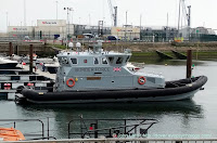
The 20m HMC Hunter, also termed CPV Hunter ('Coastal Patrol Vessel') of the UK Border Force berthed in the Inner Tidal Harbour, part of the Marina:in the Port of Dover::


Her Majesty's Cutter Hunter, also CPV Hunter ('Coastal Patrol Vessel'). One of 8 BP ARRC's (British Petroleum 'Autonomous Rescue and Recovery Craft') purchased by UK Government in 2016. In Inner Tidal Harbour of Marina with Clock Tower and former Lifeboat Station behind.
HMC Hunter on Monday the 4th of May, 2020. Camera: Google Pixel 2

Her Majesty's Cutter Speedwell, also CPV Speedwell (Coastal Patrol Vessel). One of 8 BP ARRC's (British Petroleum 'Autonomous Rescue and Recovery Craft') purchased by UK Government 2016. Inner Tidal Harbour of the Marina. Dolphin Hard and Jetty, Lifeboat RNLB 17-09 City of London II.
CPV Speedwell  MV Oceana cruise ship
A post about CPV Speedwell, who was also in port this day, is linked to on the left.

Dover Clock Tower.
Above CPV Hunter in the main photo is the clock tower, and to its left, the roof of the former lifeboat station.

Click thumbnail to see a larger size.

A Maritime Mobile Service Identity (MMSI) is a series of nine digits which are sent in digital form over a radio frequency channel in order to uniquely identify a ship or vessel.

The MMSI for CPV Hunter is 235118133 which enables her to be tracked in real-time on an AIS ('Automatic Identification System') map:


A 2017 Freedom of Information request (FOI 45061) stated:

I am able to disclose Border Force bought eight (8) x BP ARRC's ('Autonomous Rescue and Recovery Craft'), later renamed as coastal patrol vessels (CPV's) from Delta at a total cost of C£1m, these being all of the eight ex-BP vessels. As at today’s date, we have no immediate plans to purchase more. 

I have no further technical information specifically for CPV Hunter but surmise from the above that it is similar to that of HMC Active:

Built in 2006, CPV Hunter served as an Autonomous Rescue and Recovery Craft in the North Sea for supporting oil platform operations.

CPV Hunter was operated as a daughter craft from a larger offshore support vessel and launched when needed via a davit.

The design includes a deep-vee hull design constructed from fibre-reinforced plastic.

The design is also self-righting and can return to the upright position if capsized.

Propulsion: CPV Hunter is fitted with twin Caterpillar C18 engines driving twin water jets through a pair of reduction gearboxes

The total installed power of 1,288 kW (1,727 hp) gives CPV Hunter a top speed of 34 knots (63 km/h) in calm seas, or up to 24 knots (44 km/h) in seas up to 7 metres (23 ft) significant wave height.

A second view of Her Majesty's Cutter Hunter:


Her Majesty's Cutter Hunter is also called CPV Hunter ('Coastal Patrol Vessel'). One of eight BP ARRC's (British Pertoleum 'Autonomous Rescue and Recovery Craft') purchased by UK Government in 2016. DHB 'Harbour House',Wellington Dock swing-bridge, Dover Castle in view.
HMC Hunter on the 4th of May, 2020. Camera:Canon 600D DSLR

The United Kingdom Border Force is a law enforcement agency within the Home Office who secure the national borders by carrying out immigration and customs controls for people and goods entering the country.

As an example of HMC Hunter's involvement in this role, in 2019 she was involved in an incident in which twenty six people including eight children were picked up after crossing the English Channel.

Today, the Coronavirus pandemic has made the working life of her crew even more hazardous than before (not least because desperate illegal migrants are hardly in a position to practice social distancing).

My hat goes off to them as it does to those employed in another Dover "front line", Buckland Hospital.

The HMC Hunter photographs were taken from Crosswall Quay in the Port of Dover during a permitted Coronavirus bike ride.

Covid-19 lockdown: a cycling route map and biometrics can be seen on this Polar Flow web page.

Abridged versions of this post are also on Facebook and Twitter.

Sunday, 26 April 2020

White Cliffs of Dover Rockfall 2012 - 2020, Kent England UK

On the 4th of March 2012, BBC News reported that a large section of Dover's famous white cliffs had broken away and crashed into the English Channel (1)

This zoomed shot of approximately 2.5 miles from St Martin's Battery on the Western Heights shows the western terminator of the landslide as a vertical line running down the center of the photograph:


Modern view of 2012 cliff fall, or landslide at Crab Bay in the English Channel. Langdon Bay and Fan Bay are nearby, as are shipwrecks of the SS Preussen and SS Falcon. Cliff top in this region owned by National Trust.


The "smeared" cliff face to the right of the terminator is an oblique view of the area affected. Note the thin horizontal chalk crevasse on the cliff top above and beyond the top edge of the "smear" but just below the skyline.

The photo was taken about an hour before high tide and consequently it doesn't show the full height or spread of the spoil heap:


Cliff fall, or landslide from above Crab Bay into the English Channel. South Foreland lighthouse and St Margaret's-at-Cliffe are nearby. Crop of image taken with Canon 600D DSLR  and 200mm zoom lens


This section of cliffs is shown in the Rough and Ready White Cliffs of Dover Video (along with a close-up of HM Dover Coastguard station mentioned below) that was filmed at the same time as the main photo was taken.

This next photo has been extracted from the Daily Telegraph video that follows it.

The video was taken soon after the cliff collapsed in 2012 and the image shows the coastline a little  further to the east (ie out of sight of my vantage point at St Martin's Battery):


Image taken from a Daily Telegraph video of 2012 White Cliffs of Dover cliff fall near Crab Bay in the English Channel. Shows adjacent unstable area that could be the next landslide.

The "horizontal chalk crevasse" in the main photo is the top right boundary of the lozenge-shaped area of cliffs that might be where the next substantial cliff fall into the English Channel occurs.

The one-minute Daily Telegraph video, "White cliffs of Dover fall into the sea" (no commentaty):


A final photograph taken on the 22nd of July 2010 prior to the rockfall of 2012:


P&O Ferries' MV Pride of Calais ferry in the Eastern Docks of Dover harbour, Kent in 2010. Behind are White Cliffs of Dover at Crab Bay where a cliff fall into the English Channel happened in 2012.


P&O Ferries cross-channel passenger ferry, MS Pride of Calais in front of the Eastern Arm pier and Eastern Docks of Dover harbour (Port of Dover).

On the cliff top behind the ship's funnel is a foreshortened view of the top-left chalk crevasse shown in the video still; the area of the 2012 cliff fall is to its left (nearer the stern of the ship).

MS Pride of Calais was a cross-channel ferry owned and operated by P&O Ferries. She operated the Dover to Calais route between 1987 and 2012.

In early 2013, under bareboat charter to Transeuropa Ferries, she served on their Ramsgate to Ostend route and was re-named MS Ostend Spirit.

After further lay-up in the Port of Tilbury she was sold for scrap and finally beached at a salvage yard in Turkey on 13 November 2013. (3)

The White Cliffs of Dover, part of the North Downs formation, is the region of English coastline facing the Strait of Dover and France.

The cliff face, which reaches a height of 350 feet (110 m), owes its striking appearance to its composition of chalk accented by streaks of black flint.

The cliffs, on both sides of the town of Dover in Kent, stretch for eight miles (13 km). A section of coastline encompassing the cliffs was purchased by the National Trust in 2016. (4)

Also on this blog:


View of chalk cliff and English Channel from A20 roundabout with South Military Road near Archcliffe Fort.
Shakespeare Cliff
Shakespeare Cliff (west of Dover) marks the point where Great Britain most closely approaches continental Europe. On a clear day, the cliffs are easily visible from the French coast.


Photo taken during Covid-19 pandemic lockdown from A2 Jubilee Way. White Cliffs of Dover between the River Dour valley and Broadlees Bottom. Marine Parade (A20) and Athol Terrace. Part of Dover Castle on cliff top.
East Cliff and History
This panorama shows the area of White Cliffs of Dover between the River Dour valley (the town) to the left and Broadlees Bottom (A2 Jubilee Way) to the right.

The post contains close-up of three items of historical interest.

(1) Abridged from White cliffs of Dover section falls into sea:

A large section of Dover's famous white cliffs has broken away and crashed into the Channel, according to the coastguard.

Tonnes of rock collapsed into the sea between Langdon Cliffs and South Foreland Lighthouse.

Dover Coastguard said no-one was injured during the "substantial" rockfall, which happened in an area know locally as Crab Bay.

The National Trust has put up warning signs to alert walkers.

It is thought freezing conditions over the winter may have weakened the chalk cliffs.

(2) The main photograph was taken from St Martin's Battery on the Western Heights on the 24th of April during a permitted Coronavirus bike ride.

(3) Extract from MS Pride of Calais.

(4) Extract from White Cliffs of Dover 

See the Maritime and Coastguard Agency.

Covid-19 lockdown: a cycling route map and biometrics can be seen on this Polar Flow web page.

Abridged versions of this post are also on  Facebook and Twitter.

Saturday, 25 April 2020

Superyacht Sherpa 815 in the Port Of Dover, Kent, England UK

Flying the maritime red ensign,  or civil ensign of the Cayman Islands where she is registered, the MY Sherpa is shown departing Dover harbour at 11.48 am on Saturday, 25th of April 2020 en route to Gibraltar:


Support vessel for MY Hamilton II, both Superyachts owned by Jim Ratcliffe, CEO of Ineos. Sherpa is en route to Gibraltar. P&O Ferries MV Spirit of France cross-channel superferry. View from Marina Pier.


Beyond the Southern Breakwater on the left, P&O Ferries' MV Spirit of France RORO passenger ship is on a regular crossing of the English Channel to Calais in France (see below).

The Motor Yacht Sherpa began life as Project 815 in the Royal Dutch Shipyards of Feadship and is often described as a support vessel for the MY Hamilton II although she is a Superyacht in her own right.

Indeed, rather than being a "support" ship, Charter World's Coolest Superyachts around the world suggest that the MY Sherpa was built as a Superyacht for the owner's two sons. 

On this point, both the MY Hamilton II and the MY Sherpa are owned by James Ratcliffe, billionaire CEO of Ineos and reportedly the United Kingdom's richest man.

My step-mother's maiden name was Ratcliffe and I could say that's it's a pity that she wasn't related to him.

However, some residual spark of humanity prevents me from wishing such a fate upon anyone! 😀

This real-time AIS map shows the current position of the Sherpa:


 Click on the "X" in the Sherpa's information banner to see the satellite map behind

The Superyacht Times states:

Created together Cecil Wright & Partners, Project 815 (build name) is the design work of RWD who followed the owner’s brief for an industrial and highly functional exterior that is paired with a detailed interior worthy of the Feadship name.

Inside, features such as a lounge, a dining area and bar are all tucked away beneath the helicopter landing pad aft while accommodation is located in the forward part of the ship.

There is space for seven overnight guests on the main deck in an owner’s suite, two VIP suites as well as four guest cabins.

Marine Traffic MY Sherpa ship information:

IMO: 9795529
Name: SHERPA
Vessel Type - Generic: Pleasure Craft
Vessel Type - Detailed: Pleasure Craft
Status: Active
MMSI: 319139200
Call Sign: ZGHE9
Flag: Cayman Is [KY]
Gross Tonnage: -
Summer DWT: -
Length Overall x Breadth Extreme: 76 x 13 m
Year built: 2018
Also see Yacht and Harbour's Project 815.

This nighttime photo of P&O Ferries' MV Spirit of France (herself often dubbed a "superferry") was taken on the 25th of January, 2013:


Night-time view of P&O Ferries' cross-channel ferry en route to Calais in France. Leaving through the Western Entrance with the Southern Breakwater lighthouse on the left.


The MS Spirit of France has Call Sign: 2DXD5, IMO: 9533816, and MMSI: 235082717; and is sister-ferry to the MS Spirit of Britain.

The lighthouse is the Dover Southern Breakwater West End Light. Hand-held low-light ISO 3200 photo.

To find the Spirit of France's current location (present position) use the search function in the AIS Real-time Map of Ships and Other Vessels, Port of Dover, UK on this blog.

The main photo was taken during a permitted Coronavirus (alt. Covid-19) Lockdown bike ride.

A cycling route map and biometrics can be seen on this Polar Flow web page.

Abridged versions of this post are also on Facebook and Twitter.