 |
| Georgian Sergeant-Major's House |
Introduction
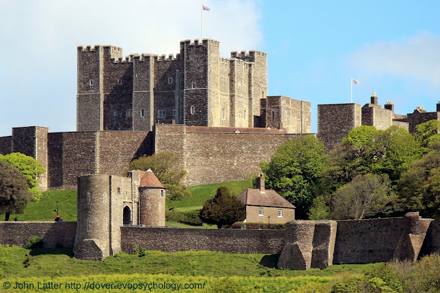
A brief description of the main photograph and the position of Peverell's Tower within it:
 |
| Photo taken during Covid-19 Lockdown cycle ride, 2nd of May, 2020. |
The central Keep was built in the late twelfth century by Maurice the Engineer during the reign of King Henry II.
The Keep Yard in which this "Great Tower" stands is surrounded by the flat-topped Inner Curtain Wall (Inner Bailey) that contains fourteen towers.
Two of these towers form the Palace Gate that is flying the English Heritage flag at top-right.
The Western Outer Curtain Wall runs across the bottom with Peverell's Tower (alt. Peverell's Gate) at bottom left.
Gatton Tower is right of center with Say Tower on the right-hand edge of the photo, both are truncated d-type towers.
Behind and to the left of Gatton Tower is the Georgian Sergeant-Major's House.
Peverell's Tower is a composite structure of King John (reigned 1199 - 1216) and King Henry III (reigned 1216 - 1272). The round tower with its conical roof is circa 1300 AD.
Peverell's Tower Holiday Cottage
English Heritage's main information page is at Staying at Peverell's Tower.
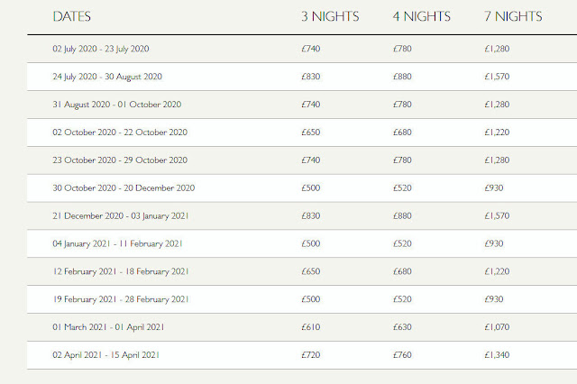
The derivative page, Availability and Prices contains the following message:
In line with the government advice on the Coronavirus outbreak (COVID-19), we’ve made the decision to close our holiday operations from Friday 20th March 2020 until Thursday 2nd July 2020.
This is the tariff from the 2nd of July 2020 until the 15th of April 2021:
If you can afford these prices then please consider taking me along as an aging boot boy ("...the lowest-ranking male servant..") - I would do anything for such a photo opportunity 😀
Otherwise I can only look at the photos and dream...
 |
| Photo taken 10th of December 2009 |
This is the classic view of Peverell's Tower seen from Knight's Road. The Georgian Sergeant-Major's House is out of shot to the right.
 |
| Constable's Gate, Queen Mary Tower |
Knight's Road changes to West Norman Road on the other side of Peverell's Tower with part of Constable's Gate visible through the arch.
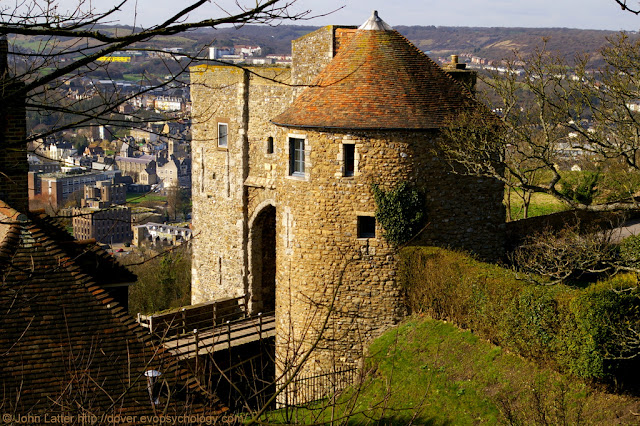
This is my favourite photo of Peverell's Tower:
 |
| Photo taken 27th of February 2011 |
There are similar photos on the internet but none quite like this because it was taken from a normally inaccessible location that gives a good view of the drawbridge.
Perhaps once a pathway, but now only a narrow strip of earth between the top of a steep slope and the outside of a high ancient wall, I was standing in a place that Saxon Geoguth (young warriors), and before them, Roman legionaries may once have patrolled.
This final photo first appeared in The Unusual Design of the Sergeant-Major's House:
 |
| Peverell's Gate Drawbridge |
It shows the Peverell Tower drawbridge and Knight's Road that leads to Canons Gate.
The Western Outer Curtain Wall and parts of Gatton's Tower, then Say's Tower are on the right.
The copper-coloured privet hedge surrounding the south garden of the Sergeant-Major's house is visible above the left-hand fence of the drawbridge.
From "The History of the Town and Port of Dover and of Dover Castle (With a Short Account of the Cinque Ports)", Volume 2. Dedicated by the Reverend John Lyon, Minister of "Saint Mary's", on April 21st, 1814, and published the same year:
This tower was built by William Peverell, of Dover, one of the confederate knights; and he had several lordships and manors granted him, in capite, which he held by castle-guard tenure.
Peverell built his tower in the angle of the exterior wall of the Saxon works; and it was constructed for defensive warfare, on every side of it. He had a noble arched gate-way, with a ditch and drawbridge, with several apartments, and over them an embattled platform for the archers.
From the interior front they could command a considerable part of the Saxon vallum; and the whole space was open to them, on the side of the hill, between the Castle and the town.
Interior photos of the holiday cottage can be seen in this English Heritage Peverell's Tower Facebook Album.
The main (first) photograph was taken on the 2nd of May, 2020 from the New Marina Pier of the Port of Dover during a permitted Coronavirus bike ride.
Covid-19 lockdown: a cycling route map and biometrics can be seen on this Polar Flow web page.
Abridged versions of this post are also on Facebook and Twitter.

No comments:
Post a Comment