Showing posts with label english channel. Show all posts

Thursday, 14 May 2020

2/2 First Covid-19 Lockdown Cycle Ride, Dover Seafront, UK

A permitted Coronavirus cycle ride along the promenade from the Eastern Docks to the New Marina Pier, Port of Dover, Kent, England, UK.

After the video there are close-ups of numbers 11 to 20 of the mainly historical local landmarks that are mentioned in the commentary.

The previous post, 1/2 First Covid-19 Lockdown Cycle Ride, contains close-ups of landmarks 1 to 10 (nb "First" in both titles indicates that I'll be making another video of the same route):


The video was filmed on Sunday, 10th of May 2020, using a head-mounted GoPro Hero 8 Black action camera and its built-in microphones.


Entrance to what was once a builder's yard in Tower Hamlets at 13 West Street, CT17 0DU, Dover, England. This is where I live and do private research into Evolution (Internal Evolutionary Mechanism), Psychology (The Archeotrauma, Trauma), and aspeccts of Social Psychology.
Time Lapse Video Start

Two days later I made a three-minute GoPro "Time Warp" (time lapse) video with commentary.

It contains a sequence that also shows the promenade from the Eastern Docks to the New Marina Pier.

Local landmarks, numbers 11 to 20:

Click on a thumbnail for a larger view, or any text link to go to the related blog post.


Victorian Waterloo Crescent Grade II Listed Building. Marine Parade. DHB's Harbour House. Best Western Dover Marina Hotel and Spa, ex-Churchill Hotel, White Cliffs Hotel (Eisenhower and Churchill in WW2), part of ex-Shalimar Hotel right. Royal Cinque Ports Yacht Club.
White Cliffs Hotel at Sunrise
Former White Cliffs Hotel, Waterloo Crescent

Where Prime Minister Churchill and President Eisenhower had dinner during the Second World War.

Now the Best Western Dover Marina Hotel and Spa.

Fairbairn Crane pre-restoration (2011)
Fairbairn Crane

Swan-neck tubular crane of 1868 on Esplanade Quay, ex-Ordnance Quay of Wellington Dock.

There's a working steam-powered version in Briatol

A Grade II Listed Building.

Triple spiral staircase linking Grand Shaft Barracks to Snargate Street. Built on Western Heights 1805-1807 in Napoleonic Wars. Lieutenant (Quartermaster) Charles Wooden, Victoria Cross, died in barracks above in 1876; he rode in Charge of the Light Brigade, Balaclava, Crimean War, 1854.
Grand Shaft, Pentax K100D  (2011)
The Grand Shaft

Triple spiral staircase built during the Napoleonic Wars.

Linked the Grand Shaft Barracks on top of the Western Heights cliffs to Snargate Street below.

Keep built 12th Century by Henry II's Norman architect, Maurice the Engineer (mason), with corner towers and pilaster buttress. English Heritage, Listed building. Medieval Royal Palace of King's Hall, King's Chamber, Guest Hall, and Guest Chamber. View from King's Gateway.
View of the Keep from King's Gate
The Keep, or Great Tower of Dover Castle

Built in AD 1180's by Maurice the Engineer for King Henry II

Contains reconstructed medieval royal palace.

English Heritage Listed Building and Ancient Monument.

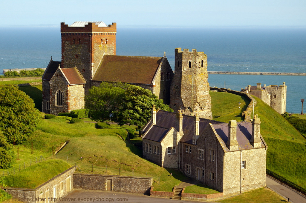
Pharos lighthouse built 46 AD, Emperor Claudius, Aulus Plautius governor. Bredenstone: Western Heights. Once St Mary-in-Castro belfry, King Lucius Church. Restored: Gilbert Scott, William Butterfield. Garrison School. Officers New Barracks or Officers Mess. Fire Beacon, English Channel.
St Mary-sub-Castro and Pharos
Saxon St Mary-in-Castro Church and Roman Pharos

Church is 10th century AD, restored by the Victorians.

Lighthouse built AD 46, reign of Emperor Claudius.

Both lie in grounds of Norman 12th century Dover Castle.

Situated on the White Cliffs of Dover overlooking the English Channel. Microwave tower, or mast on the left, radar scanner, or antenna on the right. Low roof of the operations room (control center) is in the middle.
HM Coastguard Station, Dover
HM Coast Guard Station Dover

Located at Langdon Battery, Swingate, on the White Cliffs of Dover overlooking the English Channel.

Two masts of Second World War Swingate Chain Home Radar Station, ex-RAF Swingate, now Swingate Transmitting Station. Also: Coastguard Cottages, Broadlees Bottom, A2 Jubilee Way bypass, White Cliffs of Dover, Eastern Docks, Dover harbour from Prince of Wales pier.
A2 Jubilee Way, Eastern Docks
A2 Jubilee Way Flyover

From Broadlees Bottom, low point in the White Cliffs of Dover, to the Eastern Docks.

Also World War Two Swingate radar masts and former Coast Guard Cottages.

Cross-Channel ferries in front of Eastern Arm pier with Eastern Entrance and English Channel on the right. Owner: P&O Ferries. Route: Dover to Calais (France). MS Spirit of France (departing, left). MS Pride of Canterbury (arriving, right). Port of Dover, DFDS Ferries also an operator.
In front of Eastern Arm pier (2012)
Cross-Channel Ferries

P&O Ferries' MV Spirit of France is on the left and MV Pride of Canterbury is on the right.

DFDS Ferries also operates from the Eastern Docks.

Holland America Line. From Copenhagen (Denmark), going to Amsterdam (Netherlands). Call sign PFRO, IMO 8919257. Southern Breakwater, Western Docks. Also: Western Entrance, Dover Breakwater West End Light, Admiralty Pier Lighthouse. Kent, England.
MV Maasdam, Holland America Line
Western Entrance of Dover Harbour

Southern Breakwater on the left, Admiralty Pier on the right.

Lighthouses undergoing restoration in 2010.

Prince of Wales Pier Light was built 1902. 46 feet high stone tower. Very quick flashing green light VQ, 100+ flashes per minute. Cafe behind lighthouse. Gateway Flats on seafront. Taken from above Cruise Terminal 3, Admiralty Pier, Dover Western Docks Revival.
POW Pier Lighthouse in 2010.
Prince of Wales Pier Lighthouse 

Built 1902. 46 feet high stone tower.

Very quick flashing green light VQ, 100+ flashes per minute.

Cycling route map and biometrics are on this Polar Flow web page.

Abridged versions of this post are also on Facebook and Twitter.

Monday, 11 May 2020

1/2 First Covid-19 Lockdown Cycle Ride, Dover Seafront, UK

A permitted Coronavirus cycle ride along the promenade from the Eastern Docks to the New Marina Pier, Port of Dover, Kent, England, UK.

After the video there are close-ups of numbers 1 to 10 of the mainly historical local landmarks that are mentioned in the commentary.

A second post, 2/2 First Covid-19 Lockdown Cycle Ride, contains close-ups of landmarks 11 to 20 (nb "First" in both titles indicates that I'll be making another video of the same route):


The video was filmed on Sunday, 10th of May 2020, using a head-mounted GoPro Hero 8 Black action camera and its built-in microphones.


Entrance to what was once a builder's yard in Tower Hamlets at 13 West Street, CT17 0DU, Dover, England. This is where I live and do private research into Evolution (Internal Evolutionary Mechanism), Psychology (The Archeotrauma, Trauma), and aspeccts of Social Psychology.
Time Lapse Video Start

Two days later I made a three-minute GoPro "Time Warp" (time lapse) video with commentary.

It contains a sequence that also shows the promenade from the Eastern Docks to the New Marina Pier.

Local landmarks, numbers 1 to 10:

Click on a thumbnail for a larger view, or any text link to go to the related blog post.


Georgian listed building built in 1834. Charles Lightoller moved here in 1916 in the Royal Navy's Dover Patrol, serving on the destroyer HMS Falcon. He once applied for The Spanish Prince which became a blockship in Dover Harbour in 1915.
Charles Lightoller in Dover
8 East Cliff, Marine Parade

Former home of Charles Lightoller, survivor of the 1912 RMS Titanic iceberg disaster.

Moved here in 1916 during World War One after joining the Dover Patrol.

Born 1824, educated King's School Canterbury, entered Bengal Artillery 1842. Transferred Royal Artillery after Indian Mutiny 1857. Married 1863. Made Knight Commander Order of the Bath, Queen Victoria's Diamond Jubilee 1897, died 1 East Cliff 1899.
1 East Cliff (Marine Parade), Dover
1 East Cliff, Marine Parade

Former home of General Sir Henry Le Geyt Bruce, Knight Commander of the Bath, 1824-1899.

Transferred from Bengal Artillery to Royal Artillery after 1857 Indian Mutiny.

Seaplane Station

First World War RAF or RFC squadron location.


The Mote, or Moat's Bulwark artillery battery has a semi-circular lower level or gun platform and an upper level terrace containing the West Gatehouse or Guardroon ruins. Built by King Henry VIII in 1539, one of his 'little forts'. Re-developed during the Napoleonic Wars.
Moat's Bulwark, A20 Townwall Street
Mote's Bulwark, White Cliffs below Dover Castle 

One of King Henry VIII's 'little forts' of which there were three in Dover.

The other two being the Black Bulwark and Archcliffe Fort.
Autumn (Fall) panorama of Norman Keep and Dover Castle on the Eastern Heights above River Dour valley and Dover Harbour. Houses of Victoria Park above Gateway Flats apartments. Marine Parade Gardens and promenade. History, Travel, and Tourism.
Dover Castle and Gateway Flats
The Gateway Flats

Built as a result of damage sustained during the Second World War.

The Gateway, with 221 flats that all have views of the English Channel, was completed in October 1959 at a cost of one million pounds.

Victorian former Lord Warden Hotel in the Western Docks. Built by architect Samuel Beazley between 1848-1853. Royal Navy's HMS Wasp Shore Station in World War II. Now Lord Warden House used by freight agents. Grade II Listed Building. Port of Dover, Kent, England.
Lord Warden House, DWDR
Lord Warden Hotel (now Lord Warden House)

Where Louis Blériot (link to blog post) had breakfast after the first flight across the English Channel in 1909.

Ex-HMS Wasp in World War II. Now used by freight agents.

Statue of Matthew Webb who first swam the English Channel on 25 August, 1875, symbolically resting on fish and seashell. Located on seafront between Gateway Flats and Promenade above beach. Webb died trying to swim Whirlpool Rapids below Niagara Falls 24 July 1883.
Matthew Webb, Dover Seafront
Captain Matthew Webb

Bust (or statue) symbolically rests on fishes and seashell above  plinth,

First recorded person to swim the English Channel in 1875. Died Niagara Falls 1883 (USA and Canada border).

Commemorates Rolls' non-stop return flight across English Channel, 2nd June 1910. Co-founder Rolls Royce motor cars. Statue in front of seafront Gateway Flats facing English Channel. Matthew Webb bust is nearby. Skyline: Roman Pharos, St Mary-in-Castro church, Dover Castle.
Charles Rolls facing Strait of Dover
Statue of Charles Rolls, Dover Seafront

In 1910, he became the first man to fly non-stop across the English Channel and back again.

Co-founder of the Royal Aero Club and Rolls-Royce Motor Cars.

Sculpture by Mark Humphrey on Marine Parade commemorates the 100th anniversary of the end of the Great War (World War One) on November the 11th, 1918. Camden Crescent and distant King's Arms Library shown; plinth where 'The Waiting Miner' once stood is nearby.
Every One Remembered Statue
WW1 Every One Remembered Statue

First World War Centenary Commemorative Sculpture by Mark Humphrey.

Located in Granville Gardens, symbolically facing the English Channel, France, and the Western Front beyond.

Two-dimensional silhouette statue of Jamie Clark, 2012 Olympic Torch holder; Dame Vera Lynn who sang There'll be Bluebirds over the White Cliffs of Dover in World War Two; Ian Fleming, author of 007 James Bond novels who lived at St Margaret's-at-Cliffe. Marine Parade.
Dover Seafront Promenade
Sustrans Portrait Bench, Marine Parade

Silhouette sculpture of Jamie Clark, 2012 Olympic Games Torch holder; Dame Vera Lynn (WW2 song, There'll be Bluebirds over the White Cliffs of Dover; Ian Fleming, author of 007 James Bond novels.


Cycling route map and biometrics are on this Polar Flow web page.

Abridged versions of this post are also on Facebook and Twitter.


Sunday, 26 April 2020

White Cliffs of Dover Rockfall 2012 - 2020, Kent England UK

On the 4th of March 2012, BBC News reported that a large section of Dover's famous white cliffs had broken away and crashed into the English Channel (1)

This zoomed shot of approximately 2.5 miles from St Martin's Battery on the Western Heights shows the western terminator of the landslide as a vertical line running down the center of the photograph:


Modern view of 2012 cliff fall, or landslide at Crab Bay in the English Channel. Langdon Bay and Fan Bay are nearby, as are shipwrecks of the SS Preussen and SS Falcon. Cliff top in this region owned by National Trust.


The "smeared" cliff face to the right of the terminator is an oblique view of the area affected. Note the thin horizontal chalk crevasse on the cliff top above and beyond the top edge of the "smear" but just below the skyline.

The photo was taken about an hour before high tide and consequently it doesn't show the full height or spread of the spoil heap:


Cliff fall, or landslide from above Crab Bay into the English Channel. South Foreland lighthouse and St Margaret's-at-Cliffe are nearby. Crop of image taken with Canon 600D DSLR  and 200mm zoom lens


This section of cliffs is shown in the Rough and Ready White Cliffs of Dover Video (along with a close-up of HM Dover Coastguard station mentioned below) that was filmed at the same time as the main photo was taken.

This next photo has been extracted from the Daily Telegraph video that follows it.

The video was taken soon after the cliff collapsed in 2012 and the image shows the coastline a little  further to the east (ie out of sight of my vantage point at St Martin's Battery):


Image taken from a Daily Telegraph video of 2012 White Cliffs of Dover cliff fall near Crab Bay in the English Channel. Shows adjacent unstable area that could be the next landslide.

The "horizontal chalk crevasse" in the main photo is the top right boundary of the lozenge-shaped area of cliffs that might be where the next substantial cliff fall into the English Channel occurs.

The one-minute Daily Telegraph video, "White cliffs of Dover fall into the sea" (no commentaty):


A final photograph taken on the 22nd of July 2010 prior to the rockfall of 2012:


P&O Ferries' MV Pride of Calais ferry in the Eastern Docks of Dover harbour, Kent in 2010. Behind are White Cliffs of Dover at Crab Bay where a cliff fall into the English Channel happened in 2012.


P&O Ferries cross-channel passenger ferry, MS Pride of Calais in front of the Eastern Arm pier and Eastern Docks of Dover harbour (Port of Dover).

On the cliff top behind the ship's funnel is a foreshortened view of the top-left chalk crevasse shown in the video still; the area of the 2012 cliff fall is to its left (nearer the stern of the ship).

MS Pride of Calais was a cross-channel ferry owned and operated by P&O Ferries. She operated the Dover to Calais route between 1987 and 2012.

In early 2013, under bareboat charter to Transeuropa Ferries, she served on their Ramsgate to Ostend route and was re-named MS Ostend Spirit.

After further lay-up in the Port of Tilbury she was sold for scrap and finally beached at a salvage yard in Turkey on 13 November 2013. (3)

The White Cliffs of Dover, part of the North Downs formation, is the region of English coastline facing the Strait of Dover and France.

The cliff face, which reaches a height of 350 feet (110 m), owes its striking appearance to its composition of chalk accented by streaks of black flint.

The cliffs, on both sides of the town of Dover in Kent, stretch for eight miles (13 km). A section of coastline encompassing the cliffs was purchased by the National Trust in 2016. (4)

Also on this blog:


View of chalk cliff and English Channel from A20 roundabout with South Military Road near Archcliffe Fort.
Shakespeare Cliff
Shakespeare Cliff (west of Dover) marks the point where Great Britain most closely approaches continental Europe. On a clear day, the cliffs are easily visible from the French coast.


Photo taken during Covid-19 pandemic lockdown from A2 Jubilee Way. White Cliffs of Dover between the River Dour valley and Broadlees Bottom. Marine Parade (A20) and Athol Terrace. Part of Dover Castle on cliff top.
East Cliff and History
This panorama shows the area of White Cliffs of Dover between the River Dour valley (the town) to the left and Broadlees Bottom (A2 Jubilee Way) to the right.

The post contains close-up of three items of historical interest.

(1) Abridged from White cliffs of Dover section falls into sea:

A large section of Dover's famous white cliffs has broken away and crashed into the Channel, according to the coastguard.

Tonnes of rock collapsed into the sea between Langdon Cliffs and South Foreland Lighthouse.

Dover Coastguard said no-one was injured during the "substantial" rockfall, which happened in an area know locally as Crab Bay.

The National Trust has put up warning signs to alert walkers.

It is thought freezing conditions over the winter may have weakened the chalk cliffs.

(2) The main photograph was taken from St Martin's Battery on the Western Heights on the 24th of April during a permitted Coronavirus bike ride.

(3) Extract from MS Pride of Calais.

(4) Extract from White Cliffs of Dover 

See the Maritime and Coastguard Agency.

Covid-19 lockdown: a cycling route map and biometrics can be seen on this Polar Flow web page.

Abridged versions of this post are also on  Facebook and Twitter.

Friday, 24 April 2020

Rough and Ready White Cliffs of Dover Video, Kent England UK

This one-minute video was filmed from St Martin's Battery on the Western Heights during a permitted Coronavirus Lockdown bike ride on Friday, 24th of April, 2020.

A panoramic landscape that includes zoomed shots of the cliffs and Dover Coastguard station. Final shot shows the Eastern Docks cross-channel ferry terminal and English Channel beyond:


Elsewhere in the video: Dover Castle, Dover harbour (Port of Dover), and the English Channel.

After brief comments on the White Cliffs of Dover, there are photographs showing close-ups of three points of interest in the video: a Victorian print of Langdon Bay, "Space City" (Eastern Docks) at Dawn, and the "twin Towers" of the Coastguard station.


The White Cliffs of Dover 

These cliffs which form part of the British coastline facing the Strait of Dover and France. The cliffs are part of the North Downs formation.

The cliff face, which reaches up to 107 metres (351 ft), owes its striking façade to its composition of chalk (pure white calcium carbonate) accentuated by streaks of black flint.

The cliffs spread east and west from the town of Dover in the county of Kent, an ancient and still important English port.

The cliffs have great symbolic value for Britain because they face towards Continental Europe across the narrowest part of the English Channel, where invasions have historically threatened and against which the cliffs form a symbolic guard.

Because crossing at Dover was the primary route to the continent before air travel, the white line of cliffs also formed the first or last sight of the UK for travelers.

The cliffs are located along the coastline between approximately: Latitude 51°06'N, Longitude 1°14'E and Latitude 51°12'N, Longitude 1°24'E.

View of chalk cliff and English Channel from A20 roundabout with South Military Road near Archcliffe Fort.
Shakespeare Cliff
Shakespeare Cliff (west of Dover) marks the point where Great Britain most closely approaches continental Europe. On a clear day, the cliffs are easily visible from the French coast.

The link on the left contains another of the Victorian prints shown below.

The cliffs are composed mainly of soft, white chalk with a very fine-grained texture, composed primarily of coccoliths, plates of calcium carbonate formed by coccolithophores, single-celled planktonic algae whose skeletal remains sank to the bottom of the ocean and, together with the remains of bottom-living creatures, formed sediments.

Flint, quartz, and iron pyrites ("Fools Gold") are also found in the chalk.

See the National Trust's web page about the White Cliffs of Dover.


Victorian Colour Photo of the White Cliffs of Dover, Kent UK


One of six photo-mechanical photographs held by the United States Library of Congress. This stretch of cliffs contains Langdon Bay, Crab Bay, and Fan Bay; the SS Preussen and SS Falcon are local shipwrecks.


Derived from a United States Library of Congress photo-mechanical print dated circa 1890-1900 (the above Shakespeare Cliff link has another of these prints)

From the book, The Economy of Kent (Kent History Project):

In 1900 on the White Cliffs of Dover the benefits of American cereals were advertised by two gigantic notices marked 'Quaker Oats'.

Does this photo show one of them on the cliff-top?

This stretch of cliffs contains Langdon Bay, Crab Bay, and Fan Bay; the SS Preussen and SS Falcon are local shipwrecks.


Rain at Dawn for Space City: Eastern Docks of the Port of Dover, Kent


Bounded by the Eastern Armpier, this photo also shows the White Cliffs of Dover with the A" Jubilee Way flyover emanating from Broadlees Bottom. Light trails on the A20. Georgioan houses on East Cliff (Marine Parade).


An 1800-yard zoom photo from St Martin's Battery on the Western Heights of the futuristic Eastern Docks cross-channel ferry terminal of Dover Harbour.

English Channel ferry operators: P&O Ferries and DFDS Seaways.

Shows the A2 Jubilee Way flyover and light trails on the A20 at East Cliff (Marine Parade); Dover Coastguard Station on skyline.

The photo was taken on the 17th of September, 2010.


Twin Towers of HM Dover Coastguard Station from the East, Swingate, UK


Situated on the White Cliffs of Dover overlooking the English Channel. Microwave tower, or mast on the left, radar scanner, or antenna on the right. Low roof of the operations room (control center) is in the middle.


An early morning view of the station at Langdon Battery photographed on Thursday, April the 7th, 2011.

On the right is the Radar Scanner or Antenna. A similar antenna is used by the French Coastguard at the CROSS Gris Nez Rescue Center.

On the left, 70 yards behind the radar tower, is the Microwave Radio Mast whose dishes receive additional radar data from radar sites at Fairlight (near Hastings, East Sussex) and Margate (North Kent).

Between the two towers is the sloping roof of the futuristic-looking Operations Room or Control Room.

There are other buildings and a helipad out-of-shot to the right. There is also a third, smaller mast (tower) on the station, possibly used for gathering meteorological data.

See the Maritime and Coastguard Agency.

Covid-19 lockdown: a cycling route map and biometrics can be seen on this Polar Flow web page.

Abridged versions of this post are also on Facebook and Twitter.

Wednesday, 22 April 2020

Real-time Map of Ships and Other Vessels, Port of Dover, UK

This is an interactive AIS (Automatic Identification System) map for Dover harbour with a live update feature that auto-refreshes every 600 seconds (10 minutes).

However, the map can be manually refreshed as often as required by clicking on the circular icon at bottom left:


The types of vessel that the map displays are: Cargo Vessels, Tankers, Passenger Vessels, High Speed Craft, Tugs and Special Craft, Fishing, Pleasure Craft, Navigation Aids, and Unspecified Ships.

A further two icons show if a vessel is Underway or Anchored.

Dover is noted for cross-channel ferries and cruise ships but there are no separate categories for these specific type of ships.

Disappointingly, there isn't a Nuclear-Powered Submarine category either.

Clicking on the "coffee filter" icon below the Search symbol at top left on the map shows which colour-coded symbol goes with which type, or category of vessel.

Screenshot:


Selecting, or deselecting the check-boxes of the "Vessel Filters" feature enables any combination of vessel categories to be displayed (the above screenshot has all categories selected).

AIS is intended, primarily, to allow ships to view marine traffic in their area and to be seen by that traffic.

This requires a dedicated VHF AIS transceiver that allows local traffic to be viewed on an AIS enabled chart plotter or computer monitor while transmitting information about the ship itself to other AIS receivers.

Port authorities or other shore-based facilities may be equipped with receivers only, so that they can view the local traffic without the need to transmit their own location.

All AIS transceivers equipped traffic can be viewed this way very reliably but is limited to the VHF range, about 10 to 20 nautical miles.

Panorama of Dover Harbour from the Western Heights on the 15th of April, 2020:

View from St Martin's Battery on the Western Heights. Shows White Cliffs of Dover beyond Eastern Docks and Eastern Arm Pier, Southern Breakwater, new Marina pier, Dover Western Docks Revival, part of Admiralty pier, Wellington Dock, Granville Dock and seafront.

The White Cliffs of Dover are beyond the Eastern Docks and Eastern Arm pier on the left.

The English Channel is beyond the Southern Breakwater in the center, and the Dover Western Docks Revival project is right of center.

Wellington Dock and Granville Dock of Dover Marina are behind the seafront and DWDR area.

About the Port of Dover

The Port of Dover is Europe’s busiest ferry port, a vital international gateway for the movement of people and trade.

It is also an award-winning cruise port, the second busiest in the UK and hosts some of the world’s most prestigious cruise lines.

Other successful businesses include a cargo terminal, a top award-winning marina and several niche activities. The business mix is diverse.

Also see Port of Dover  on Wikipedia and Dover Harbour at Dover Museum.

The main photo was taken during a permitted Coronavirus (alt. Covid-19) Lockdown bike ride.

A cycling route map and biometrics can be seen on this Polar Flow web page.

Abridged versions of this post are also on Facebook and Twitter.

Saturday, 18 April 2020

Arcadia Cruise Ship Video, Port of Dover, 18 April 2020, UK

The P&O Cruises ship, MS Arcadia entering the English Channel through the Western Entrance of Dover harbour (Port of Dover) after arriving here from Southanpton three days ago.

The Southern Breakwater is on the left and Admiralty Pier on the right.

There are no passengers on board the MS Arcadia, of course, because of the Coronavirus Pandemic Lockdown:


The Arcadia returned to Dover just before 4 am the following day (Sunday, 19th of April, 2020).

This P&O Cruises passengher ship is shown backlit at Berth C in the Cargo Area of the new Western Docks development of the Port of Dover. The ship is here because of the Covid-19 Pandemic Lockdown restrictions.
MS Arcadia at Berth C
Instead of returning to the Eastern Arm Pier where she had previously been berthed, the ship moored at Berth C in the Cargo Area of the new Western Docks development.

Two photos of the passenger ship in her new position (taken from the Marina Pier) can be seen by clicking on the thumbnail to the left.

MV Arcadia was ordered by Holland America Line in 2000 as their fifth Vista-class vessel.

In 2003 she was allocated to Cunard Line to become their Queen Victoria.

Shortly before her launch the decision was made to transfer the ship to the P&O Cruises fleet. As a result, Arcadia has a Cunard-style mast similar to those found on RMS Queen Elizabeth 2 and RMS Queen Mary 2.

She also sports a modified Queen Elizabeth 2-style funnel, with cowling removed instead of the traditional P&O style funnel found on the purpose-built Oriana and Aurora.

The passenger ship Arcadia, along with Oriana, are adult-only ships. This real-time AIS map shows her current position:


 Click on the "X" in the Arcadia's information banner to see the satellite map behind

Ship Details:

Name:    Arcadia
Namesake:    The region of Arcadia (Greece)
Owner:    Carnival plc
Operator:    P&O Cruises

Identification:

    Call sign: ZCDN2
    IMO number: 9226906
    MMSI number: 310459000

Port of registry:     Hamilton, Bermuda
Ordered:    2000
Builder:    Fincantieri (Porto Marghera, Italy)

Cost:    USD 400 million
Yard number:    6078
Laid down:    12 July 2003
Launched:    26 June 2004
Acquired:    29 March 2005
In service:    April 2005

Status:    In service

The video was made during a permitted Covid-19 Lockdown bike ride.

A cycling route map and biometrics can be seen on this Polar Flow web page.

Abridged versions of this post are also on Facebook and Twitter.

Source: MV Arcadia

Wednesday, 15 April 2020

Panorama of Shakespeare Cliff and English Channel, Dover, UK

Two photographs with similar views of an iconic natural landmark: one taken during a Coronavirus Lock Down bike ride, and the other, a Victorian photo-mechanical print dated circa 1890-1900.

1) Shakespeare Cliff on the 15th of April, 2020

View of chalk cliff and English Channel from A20 roundabout with South Military Road near Archcliffe Fort.

The headland jutting out into the English Channel, previously known as Hay Cliff, Hay Hill, and with various alternate spellings ("Shakespeare Cliffe", "Shakspere Cliff", etc.), marks the point where Great Britain most closely approaches continental Europe, specifically France.

The cliff was renamed as a result of William Shakespeare's references to it in his tragedy, King Lear (based on the legend of Leir of Britain, a mythological pre-Roman Celtic king).

King Lear

Act IV, Scene I ("The Heath")

EARL OF GLOUCESTER (sometimes GLOSTER)

Dost thou know Dover?

EDGAR (SON OF GLOUCESTER)

Ay, master.

GLOUCESTER

There is a cliff, whose high and bending head Looks fearfully in the confined deep: Bring me but to the very brim of it, And I'll repair the misery thou dost bear With something rich about me: from that place I shall no leading need.

EDGAR

Give me thy arm: Poor Tom shall lead thee.

In Act IV, Scene VI ("Fields near Dover"), Edgar has deceived the blinded Gloucester into believing he is on the edge of Shakespeare Cliff:

EDGAR

Come on, sir; here's the place: stand still. How fearful And dizzy 'tis, to cast one's eyes so low! The crows and choughs that wing the midway air Show scarce so gross as beetles: half way down Hangs one that gathers samphire, dreadful trade! 

Methinks he seems no bigger than his head: The fishermen, that walk upon the beach, Appear like mice; and yond tall anchoring bark, Diminish'd to her cock; her cock, a buoy Almost too small for sight: the murmuring surge, That on the unnumber'd idle pebbles chafes, Cannot be heard so high. I'll look no more; Lest my brain turn, and the deficient sight Topple down headlong.

GLOUCESTER

Set me where you stand.

EDGAR

Give me your hand: you are now within a foot Of the extreme verge: for all beneath the moon Would I not leap upright.

GLOUCESTER

Let go my hand...

2) Victorian view of Shakespeare Cliff

USA Library of Congress photo-mechanical print 1890-1900. South-Eastern Railway (1836-1922) tunnels.

Derived from a United States Library of Congress photo-mechanical print dated circa 1890-1900.

Intriguing lattice tower or mast in the distance: Marconi made the first ship to shore radio transmission from nearby South Foreland Lighthouse (several miles behind the viewer, on the other side of Dover) in 1898,

French government didn't allow wireless telegraphy across English Channel until 1899. What and when could this tower be? A military signalling (eg semaphore) station?

A cycling route map and biometrics during which I took the first photo can be seen on this Polar Flow web page.

Abridged versions of this post are also on Facebook and Twitter.

Tuesday, 7 April 2020

Unusual view of Saxon Church, Roman Pharos in Dover Castle, UK

"Unusual" in that the photo is a zoomed shot from some 800 yards away, not far from the edge of the White Cliffs of Dover (see map below), and also because there isn't anything similar in Google Images.

The Roman lighthouse is located behind the church on the right. Both structures are Grade I Listed Buildings, as is Dover Castle itself:


View from 800 yards of 10th century Saxon church, restored twice by the Victorians. Also called King Lucius church. Roman Pharos built AD 46 during  Emperor Claudius' reign. Church and lighthouse built on Bronze Age mound. A coronavirus, covid-19 lockdown bike ride.


Dover Castle is owned by English Heritage and is a scheduled Ancient Monument.

1) The church of St Mary-in-Castro [Note 1]

The latest possible date for the foundation of the church is circa 1020AD.

The exterior is of 2 storeys flint with some reused Roman brick window dressings and some modern ashlar dressings. Modern tiled roof and restored tower.

The Church was roofless and used as a coalstore in the 18th century but was restored for use as a garrison church to the Castle by Sir Gilbert Scott in 1862.

The interior contains a Chancel arch of Roman brick, a blocked Saxon doorway and the site of a Military or soldiers altar of A.D. 1225.

There is a Victorian wooden roof and stained glass windows. Mosaics by Butterfield 1888.


Pharos lighthouse built 46 AD, Emperor Claudius, Aulus Plautius governor. Bredenstone: Western Heights. Once St Mary-in-Castro belfry, King Lucius Church. Restored: Gilbert Scott, William Butterfield. Garrison School. Officers New Barracks or Officers Mess. Fire Beacon, English Channel.
Garrison school in foreground; Officers New Quarters, Fire Beacon, and English Channel beyond (2011).

2) The Roman Pharos (lighthouse) [Note 2]

Built in AD 46 under the Emperor Claudius.

This guided the Roman fleet round to the port of Richborough.

In mediaeval (alt. medieval) times it was used as a belfry to the Church of St Mary Sub-Castro.

4 stories, 3 being Roman and the top storey and remains of battlements mediaeval.

An octagonal tower with originally vertical stepped walls rising in tiers set back each within the last, now almost smoothed.

Rubble with a facing of green sandstone and tufa and levelled at an interval of 7 courses with a double course of brick set in hard pink mortar.

Round-headed windows with a small recessed spy-hole inside them.

The location the first photo was taken from is marked "P3" on the cycling route map of 1st April 2020:


 Bike ride route map for 1st April, 2020. 6 Robsons Yard (Tower Hamlets) to Dover Castle and then the White Cliffs of Dover above the Eastern Docks. Then on to the "Ornamental Boat" at St Margaret's-at-Cliffe that commemorates the 2012 London Olympic Games. Returned via same roads.


Start and end point of cycle ride is the green dot below the "S" near bottom left.

Original map and biometrics at Polar Flow

Abbreviated versions of this post are also on Facebook and Twitter.

More information on this ancient monument: Dover Castle at English Heritage

Permitted cycle ride under the Coronavirus (Covid-19) lockdown rules.   

[Note 1] Abridged from St Mary Sub-Castro

[Note 2] Abridged from The Roman Pharos