A panoramic landscape that includes zoomed shots of the cliffs and Dover Coastguard station. Final shot shows the Eastern Docks cross-channel ferry terminal and English Channel beyond:
Elsewhere in the video: Dover Castle, Dover harbour (Port of Dover), and the English Channel.
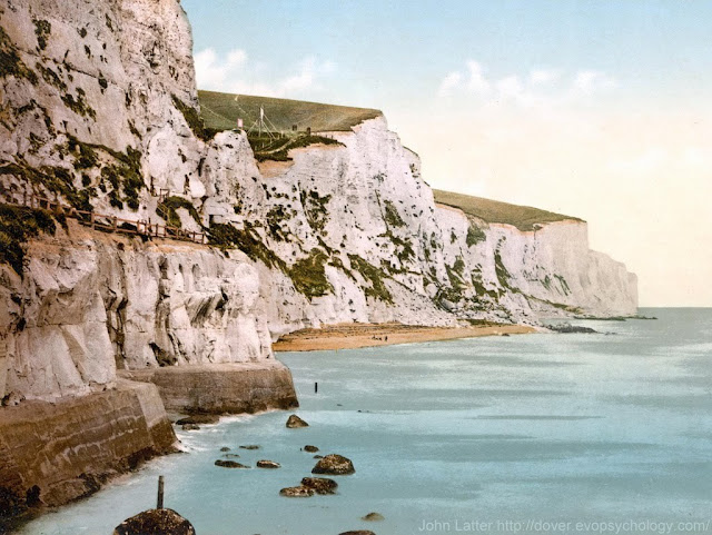
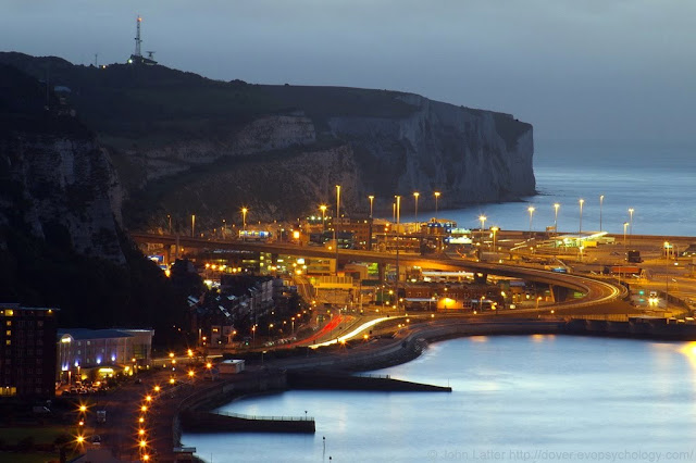
After brief comments on the White Cliffs of Dover, there are photographs showing close-ups of three points of interest in the video: a Victorian print of Langdon Bay, "Space City" (Eastern Docks) at Dawn, and the "twin Towers" of the Coastguard station.
The White Cliffs of Dover
These cliffs which form part of the British coastline facing the Strait of Dover and France. The cliffs are part of the North Downs formation.
The cliff face, which reaches up to 107 metres (351 ft), owes its striking façade to its composition of chalk (pure white calcium carbonate) accentuated by streaks of black flint.
The cliffs spread east and west from the town of Dover in the county of Kent, an ancient and still important English port.
The cliffs have great symbolic value for Britain because they face towards Continental Europe across the narrowest part of the English Channel, where invasions have historically threatened and against which the cliffs form a symbolic guard.
Because crossing at Dover was the primary route to the continent before air travel, the white line of cliffs also formed the first or last sight of the UK for travelers.
The cliffs are located along the coastline between approximately: Latitude 51°06'N, Longitude 1°14'E and Latitude 51°12'N, Longitude 1°24'E.
 |
| Shakespeare Cliff |
The link on the left contains another of the Victorian prints shown below.
The cliffs are composed mainly of soft, white chalk with a very fine-grained texture, composed primarily of coccoliths, plates of calcium carbonate formed by coccolithophores, single-celled planktonic algae whose skeletal remains sank to the bottom of the ocean and, together with the remains of bottom-living creatures, formed sediments.
Flint, quartz, and iron pyrites ("Fools Gold") are also found in the chalk.
See the National Trust's web page about the White Cliffs of Dover.
Victorian Colour Photo of the White Cliffs of Dover, Kent UK
Derived from a United States Library of Congress photo-mechanical print dated circa 1890-1900 (the above Shakespeare Cliff link has another of these prints)
From the book, The Economy of Kent (Kent History Project):
In 1900 on the White Cliffs of Dover the benefits of American cereals were advertised by two gigantic notices marked 'Quaker Oats'.
Does this photo show one of them on the cliff-top?
This stretch of cliffs contains Langdon Bay, Crab Bay, and Fan Bay; the SS Preussen and SS Falcon are local shipwrecks.
Rain at Dawn for Space City: Eastern Docks of the Port of Dover, Kent
An 1800-yard zoom photo from St Martin's Battery on the Western Heights of the futuristic Eastern Docks cross-channel ferry terminal of Dover Harbour.
English Channel ferry operators: P&O Ferries and DFDS Seaways.
Shows the A2 Jubilee Way flyover and light trails on the A20 at East Cliff (Marine Parade); Dover Coastguard Station on skyline.
The photo was taken on the 17th of September, 2010.
Twin Towers of HM Dover Coastguard Station from the East, Swingate, UK
An early morning view of the station at Langdon Battery photographed on Thursday, April the 7th, 2011.
On the right is the Radar Scanner or Antenna. A similar antenna is used by the French Coastguard at the CROSS Gris Nez Rescue Center.
On the left, 70 yards behind the radar tower, is the Microwave Radio Mast whose dishes receive additional radar data from radar sites at Fairlight (near Hastings, East Sussex) and Margate (North Kent).
Between the two towers is the sloping roof of the futuristic-looking Operations Room or Control Room.
There are other buildings and a helipad out-of-shot to the right. There is also a third, smaller mast (tower) on the station, possibly used for gathering meteorological data.
See the Maritime and Coastguard Agency.
Covid-19 lockdown: a cycling route map and biometrics can be seen on this Polar Flow web page.
Abridged versions of this post are also on Facebook and Twitter.


No comments:
Post a Comment